IMAGES TAKEN NEAR TO
Chapel Lane, CANTERBURY, CT4 6YB
Introduction
This page details the photographs taken nearby to Chapel Lane, CT4 6YB by members of the Geograph project.
The Geograph project started in 2005 with the aim of publishing, organising and preserving representative images for every square kilometre of Great Britain, Ireland and the Isle of Man.

There are currently over 7.5m images from over14,400 individuals and you can help contribute to the project by visiting https://www.geograph.org.uk
Image Map
Images are licensed for reuse under creativecommons.org/licenses/by-sa/2.0
Notes
- Clicking on the map will re-center to the selected point.
- The higher the marker number, the further away the image location is from the centre of the postcode.
Image Listing (5 Images Found)
Images are licensed for reuse under creativecommons.org/licenses/by-sa/2.0
Image
Details
Distance
1
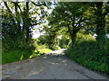
Lane between Chapel Lane and Magpie Lane near Elham
A short, narrow lane that goes past Mount Farm and Lower Mount Farm towards Elham.
Image: © pam fray
Taken: 9 Oct 2015
0.13 miles
3
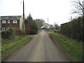
Mount Hill near Elham
Looking towards Mount Farm.
Image: © pam fray
Taken: 9 Oct 2015
0.16 miles
4
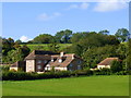
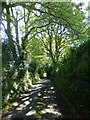
Lower Mount Farm, Rhodes Minnis
Looking across to Mount Hill where the farmhouse stands. Taken from Magpie Lane.
Image: © pam fray
Taken: 9 Oct 2015
0.19 miles