IMAGES TAKEN NEAR TO
Mill Hill, CANTERBURY, CT4 6XG
Introduction
This page details the photographs taken nearby to Mill Hill, CT4 6XG by members of the Geograph project.
The Geograph project started in 2005 with the aim of publishing, organising and preserving representative images for every square kilometre of Great Britain, Ireland and the Isle of Man.

There are currently over 7.5m images from over14,400 individuals and you can help contribute to the project by visiting https://www.geograph.org.uk
Image Map
Images are licensed for reuse under creativecommons.org/licenses/by-sa/2.0
Notes
- Clicking on the map will re-center to the selected point.
- The higher the marker number, the further away the image location is from the centre of the postcode.
Image Listing (5 Images Found)
Images are licensed for reuse under creativecommons.org/licenses/by-sa/2.0
Image
Details
Distance
2
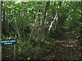
Aconite Wood
This private wood is part of Tye Wood. The track on the right is a footpath through the wood leading from Elham towards Magpie Lane, near Rhodes Minnis.
Image: © David Anstiss
Taken: 10 Oct 2010
0.21 miles
3
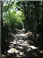
Boyke Lane
This lane leads down from Rhodes Minnis to Ottinge.
Image: © David Anstiss
Taken: 10 Oct 2010
0.23 miles
4
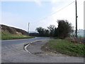
Junction between minor road and Canterbury Road south of Elham
Image: © nick macneill
Taken: 4 Mar 2011
0.24 miles
5
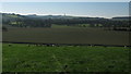
View of Tolsford Hill Radio Station Mast
Seen from Boyke Lane.
Image: © David Anstiss
Taken: 10 Oct 2010
0.24 miles