IMAGES TAKEN NEAR TO
Park Lane, CANTERBURY, CT4 6UR
Introduction
This page details the photographs taken nearby to Park Lane, CT4 6UR by members of the Geograph project.
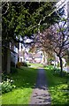
The Geograph project started in 2005 with the aim of publishing, organising and preserving representative images for every square kilometre of Great Britain, Ireland and the Isle of Man.

There are currently over 7.5m images from over14,400 individuals and you can help contribute to the project by visiting https://www.geograph.org.uk
Image Map
Images are licensed for reuse under creativecommons.org/licenses/by-sa/2.0
Notes
- Clicking on the map will re-center to the selected point.
- The higher the marker number, the further away the image location is from the centre of the postcode.
Image Listing (113 Images Found)
Images are licensed for reuse under creativecommons.org/licenses/by-sa/2.0
Image
Details
Distance
1
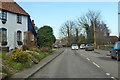
High Street, Elham
Towards Canterbury, towards the north end of the village.
Image: © Robin Webster
Taken: 7 Feb 2020
0.04 miles
2
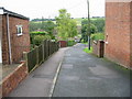
Elham village hall
There are tennis courts to the left of the photo, just beyond the hall.
Image: © Nick Smith
Taken: 9 Jun 2008
0.06 miles
3
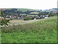
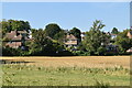
Looking NE towards housing at the north of Elham
The houses are on Fairfield and Park Lane.
Image: © Nick Smith
Taken: 7 Sep 2008
0.07 miles
4
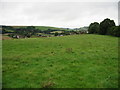
View from footpath towards Fairfield and Park Lane
Image: © Nick Smith
Taken: 7 Sep 2008
0.08 miles
6
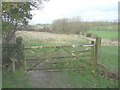
Gate and stile on the Elham Valley Way
One comes upon these at the end of a track off Cherry Gardens.
Image: © John Baker
Taken: 10 Feb 2014
0.09 miles
7
Elham High Street (North End)
Taken facing north.
Image: © Stephen Nunney
Taken: Unknown
0.11 miles
8
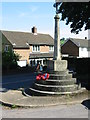
Elham war memorial
On the junction of High Street and The Row
Image: © Nick Smith
Taken: 9 Jun 2008
0.11 miles