IMAGES TAKEN NEAR TO
The Row, CANTERBURY, CT4 6UP
Introduction
This page details the photographs taken nearby to The Row, CT4 6UP by members of the Geograph project.
The Geograph project started in 2005 with the aim of publishing, organising and preserving representative images for every square kilometre of Great Britain, Ireland and the Isle of Man.

There are currently over 7.5m images from over14,400 individuals and you can help contribute to the project by visiting https://www.geograph.org.uk
Image Map
Images are licensed for reuse under creativecommons.org/licenses/by-sa/2.0
Notes
- Clicking on the map will re-center to the selected point.
- The higher the marker number, the further away the image location is from the centre of the postcode.
Image Listing (200 Images Found)
Images are licensed for reuse under creativecommons.org/licenses/by-sa/2.0
Image
Details
Distance
1
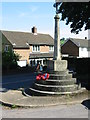
Elham war memorial
On the junction of High Street and The Row
Image: © Nick Smith
Taken: 9 Jun 2008
0.03 miles
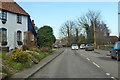
2

Elham High Street (North End)
Taken facing north.
Image: © Stephen Nunney
Taken: Unknown
0.03 miles
3
High Street, Elham
Towards Canterbury, towards the north end of the village.
Image: © Robin Webster
Taken: 7 Feb 2020
0.06 miles
4
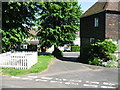
Link road between The Row and High Street
The little square of white fencing contains a small well, but it is rather over exposed on the photo.
Image: © Nick Smith
Taken: 9 Jun 2008
0.06 miles
5
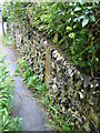
Walled footpath from The Row
The wall was mainly flint and brick but also had lots of broken pottery, mugs, parts of a tea pot and bottles built in.
Image: © Nick Smith
Taken: 7 Sep 2008
0.06 miles
6
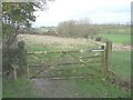
Gate and stile on the Elham Valley Way
One comes upon these at the end of a track off Cherry Gardens.
Image: © John Baker
Taken: 10 Feb 2014
0.07 miles
7
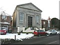
The Methodist Church, High Street, Elham
The building is dated 1839. The building on the right, attached to the church, dates from the 18th-century and was The Old Chapel.
Image: © John Baker
Taken: 4 Feb 2012
0.07 miles
9
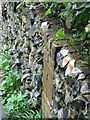
Detail of a wall alongside a footpath from The Row
Detail of the wall in http://www.geograph.org.uk/photo/991927 showing some of the things built into it.
Image: © Nick Smith
Taken: 7 Sep 2008
0.07 miles
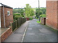
10
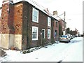
Cottages, The Row, Elham
The nearest building is Oxenden Cottage and the furthest Southdown Cottages. In between was The Old Chapel but this has been demolished. Planning permission has been approved, with conditions, by Folkestone and Hythe District Council under application number Y08/0023/SH for the “erection of a dwelling house (alternative to Y05/1220/SH)”. This is in the process of being built.
Image: © John Baker
Taken: 4 Feb 2012
0.07 miles