IMAGES TAKEN NEAR TO
Vicarage Lane, CANTERBURY, CT4 6TX
Introduction
This page details the photographs taken nearby to Vicarage Lane, CT4 6TX by members of the Geograph project.
The Geograph project started in 2005 with the aim of publishing, organising and preserving representative images for every square kilometre of Great Britain, Ireland and the Isle of Man.

There are currently over 7.5m images from over14,400 individuals and you can help contribute to the project by visiting https://www.geograph.org.uk
Image Map
Images are licensed for reuse under creativecommons.org/licenses/by-sa/2.0
Notes
- Clicking on the map will re-center to the selected point.
- The higher the marker number, the further away the image location is from the centre of the postcode.
Image Listing (118 Images Found)
Images are licensed for reuse under creativecommons.org/licenses/by-sa/2.0
Image
Details
Distance
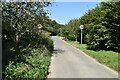
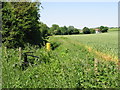
3
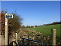
The Elham Valley Way
Part of the path that runs south of the village of Elham.
Image: © pam fray
Taken: 31 Dec 2014
0.03 miles