IMAGES TAKEN NEAR TO
Duck Street, CANTERBURY, CT4 6TW
Introduction
This page details the photographs taken nearby to Duck Street, CT4 6TW by members of the Geograph project.
The Geograph project started in 2005 with the aim of publishing, organising and preserving representative images for every square kilometre of Great Britain, Ireland and the Isle of Man.

There are currently over 7.5m images from over14,400 individuals and you can help contribute to the project by visiting https://www.geograph.org.uk
Image Map
Images are licensed for reuse under creativecommons.org/licenses/by-sa/2.0
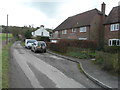
Notes
- Clicking on the map will re-center to the selected point.
- The higher the marker number, the further away the image location is from the centre of the postcode.
Image Listing (236 Images Found)
Images are licensed for reuse under creativecommons.org/licenses/by-sa/2.0
Image
Details
Distance
1
Site of Elham railway station
The station opened 4 July 1887 and closed on 1 February 1940, while the whole of the Elham Valley Line was closed on 1 October 1947 http://www.disused-stations.org.uk/e/elham/index.shtml As the link reads, remains of the ‘up’ platform are sometimes visible and this is the case here. The northeast end is just visible on the right hand side of the frame.
Image: © John Baker
Taken: 21 Jan 2015
0.02 miles
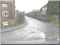
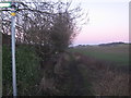
2
Looking north-northeast along the Elham Valley Way
Here it runs beside the Nail Bourne, which has become swollen as a result of weeks of torrential rain and has flooded the path.
Image: © John Baker
Taken: 10 Feb 2014
0.03 miles
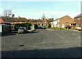
3
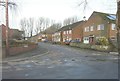
Water Farm
A small group of houses in a cul-de-sac built on land that was once part of Image The entrance to this cul-de-sac can be seen in that shot.
Image: © John Baker
Taken: 15 Jan 2013
0.03 miles
4
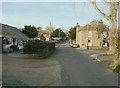
Water Farm, Duck Street, Elham
Looking up the street towards the church of St Mary the Virgin. Water Farm (now a private house) dating from around 1580, is the large building on the right.
Image: © John Baker
Taken: 17 Jan 2012
0.03 miles
5
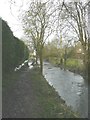
Elham Valley Way towards North Elham
The long distance path leads from Duck Street (in Elham) towards North Elham along the Elham Valley. This section of the path follows the route of the dismantled Elham Valley Railway.
Image: © David Anstiss
Taken: 9 Jan 2011
0.04 miles
6
The Orchards, Elham
As seen from the Elham Valley Way with the spire of St Mary the Virgin in the distance. This small estate is accessed from Duck Street.
Image: © John Baker
Taken: 17 Jan 2012
0.04 miles
7
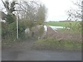
A flooded Elham Valley Way
Seen from Duck Street, the culprit for this flooding lies to its left – the Nail Bourne.
Image: © John Baker
Taken: 10 Feb 2014
0.04 miles
8
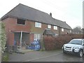
1 The Halt, Duck Street, Elham
Planning permission has been approved, with conditions, by Folkestone and Hythe District Council under application number Y/12/0717/SH for the “erection of a two-storey side extension, a single storey rear extension, cladding to first floor front elevation and conversion of the existing garage to ancillary living accommodation”.
Image: © John Baker
Taken: 24 Dec 2013
0.04 miles
9
1, The Halt, Duck Street
Compared with Image, this view shows a newly built balcony. Planning permission was approved, with conditions, by Folkestone and Hythe District Council under application number Y14/0435/SH as a “section 73 application to vary condition 2 of planning permission Y12/0717/SH (erection of a two-storey side extension, a single storey rear extension, cladding to first floor front elevation and conversion of the existing garage to ancillary living accommodation) to enable the design to be amended including alterations to the fenestration to the proposed rear extension, provision of balcony to first floor front elevation and cladding to rear elevation”.
Image: © John Baker
Taken: 23 Feb 2016
0.04 miles
10
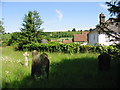
Looking E across the graveyard at St Mary the Virgin church
Image: © Nick Smith
Taken: 9 Jun 2008
0.05 miles