IMAGES TAKEN NEAR TO
Vicarage Lane, CANTERBURY, CT4 6TT
Introduction
This page details the photographs taken nearby to Vicarage Lane, CT4 6TT by members of the Geograph project.
The Geograph project started in 2005 with the aim of publishing, organising and preserving representative images for every square kilometre of Great Britain, Ireland and the Isle of Man.

There are currently over 7.5m images from over14,400 individuals and you can help contribute to the project by visiting https://www.geograph.org.uk
Image Map
Images are licensed for reuse under creativecommons.org/licenses/by-sa/2.0
Notes
- Clicking on the map will re-center to the selected point.
- The higher the marker number, the further away the image location is from the centre of the postcode.
Image Listing (228 Images Found)
Images are licensed for reuse under creativecommons.org/licenses/by-sa/2.0
Image
Details
Distance
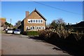
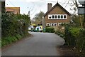
3
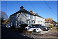
Houses off Vicarage Lane
The church of St Mary the Virgin in the background
Image: © Nick Smith
Taken: 9 Jun 2008
0.01 miles
4
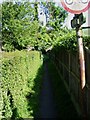
Footpath from the corner of Vicarage Lane
The path links in to the Elham Valley Way.
Image: © Nick Smith
Taken: 9 Jun 2008
0.01 miles
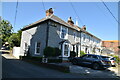
5
Lickpot Hill (road) joins Vicarage Lane, Elham
Image: © Ian S
Taken: 12 Feb 2020
0.01 miles
6
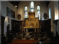
The altar in St Mary the Virgin church, Elham
Image: © Nick Smith
Taken: 6 Sep 2008
0.01 miles
7
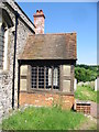
Porch on the church of St Mary the Virgin
Image: © Nick Smith
Taken: 9 Jun 2008
0.01 miles
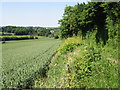
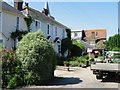
10
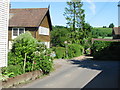
Corner of Vicarage Lane, Elham
There is a footpath running due E from the corner of the lane, (the green footpath sign is just visible below the no cycling sign).
Image: © Nick Smith
Taken: 9 Jun 2008
0.02 miles