IMAGES TAKEN NEAR TO
Duck Street, CANTERBURY, CT4 6TN
Introduction
This page details the photographs taken nearby to Duck Street, CT4 6TN by members of the Geograph project.
The Geograph project started in 2005 with the aim of publishing, organising and preserving representative images for every square kilometre of Great Britain, Ireland and the Isle of Man.

There are currently over 7.5m images from over14,400 individuals and you can help contribute to the project by visiting https://www.geograph.org.uk
Image Map
Images are licensed for reuse under creativecommons.org/licenses/by-sa/2.0
Notes
- Clicking on the map will re-center to the selected point.
- The higher the marker number, the further away the image location is from the centre of the postcode.
Image Listing (235 Images Found)
Images are licensed for reuse under creativecommons.org/licenses/by-sa/2.0
Image
Details
Distance
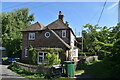
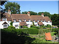
1
St Mary's Cottages, Duck Street, Elham
These cottages date from the 18th century.
Image: © John Baker
Taken: 17 Jan 2012
0.01 miles
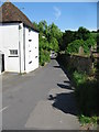
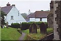
4
Houses on Duck Street from the churchyard
Image: © Nick Smith
Taken: 9 Jun 2008
0.03 miles
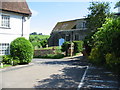
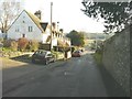
5
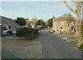
Water Farm, Duck Street, Elham
Looking up the street towards the church of St Mary the Virgin. Water Farm (now a private house) dating from around 1580, is the large building on the right.
Image: © John Baker
Taken: 17 Jan 2012
0.03 miles