IMAGES TAKEN NEAR TO
Wick Lane, CANTERBURY, CT4 6SD
Introduction
This page details the photographs taken nearby to Wick Lane, CT4 6SD by members of the Geograph project.
The Geograph project started in 2005 with the aim of publishing, organising and preserving representative images for every square kilometre of Great Britain, Ireland and the Isle of Man.

There are currently over 7.5m images from over14,400 individuals and you can help contribute to the project by visiting https://www.geograph.org.uk
Image Map
Images are licensed for reuse under creativecommons.org/licenses/by-sa/2.0
Notes
- Clicking on the map will re-center to the selected point.
- The higher the marker number, the further away the image location is from the centre of the postcode.
Image Listing (18 Images Found)
Images are licensed for reuse under creativecommons.org/licenses/by-sa/2.0
Image
Details
Distance
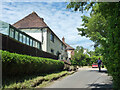
2
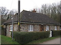
Woodside Cottage
On Wick Lane.
Woolwich Wood is in the background.
Image: © David Anstiss
Taken: 30 Jan 2011
0.02 miles
4
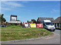
Road closure, Woolage Green
The road some way along was dug up for gas purposes.
Image: © Robin Webster
Taken: 4 Jun 2015
0.04 miles
5

1 of 2 Two Sawyers Pub Signs, Woolage Green
This sign is in the public house's car park.
Image: © David Anstiss
Taken: 30 Jan 2011
0.04 miles
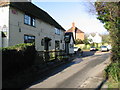
6
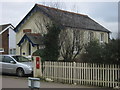
Chapel Cottage, Woolage Green
Converted chapel on Forstal Road.
Image: © David Anstiss
Taken: 30 Jan 2011
0.05 miles
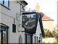
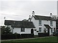
7
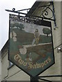
The 2nd - Two Sawyers Pub Sign, Woolage Green
This pub sign is attached to the building.
See also Image
Image: © David Anstiss
Taken: 30 Jan 2011
0.07 miles