IMAGES TAKEN NEAR TO
Wick Lane, CANTERBURY, CT4 6SB
Introduction
This page details the photographs taken nearby to Wick Lane, CT4 6SB by members of the Geograph project.
The Geograph project started in 2005 with the aim of publishing, organising and preserving representative images for every square kilometre of Great Britain, Ireland and the Isle of Man.

There are currently over 7.5m images from over14,400 individuals and you can help contribute to the project by visiting https://www.geograph.org.uk
Image Map (Loading...)


Getting Data...Please wait
Leaflet Map data © OpenStreetMap
Images are licensed for reuse under creativecommons.org/licenses/by-sa/2.0
Notes
- Clicking on the map will re-center to the selected point.
- The higher the marker number, the further away the image location is from the centre of the postcode.
Image Listing (9 Images Found)
Images are licensed for reuse under creativecommons.org/licenses/by-sa/2.0
Image
Details
Distance
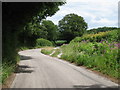
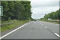
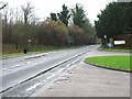
1
Junction of Wick Lane with the S bound carriageway of the A2
Image: © Nick Smith
Taken: 14 Jan 2007
0.02 miles
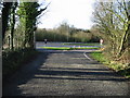
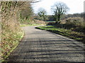
2
Junction of Rose Lane off Bonny Bush Hill
Image: © Nick Smith
Taken: 11 Feb 2007
0.09 miles
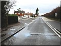
4
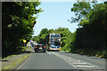
16 bus on A260 Canterbury Road
Going to Hythe via Hawkinge and Folkestone.
Image: © Robin Webster
Taken: 29 Jun 2019
0.10 miles
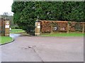
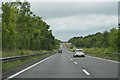
8
Looking S towards Denton from the entrance to Barham Crematorium
Image: © Nick Smith
Taken: 11 Feb 2007
0.22 miles