IMAGES TAKEN NEAR TO
Wootton Lane, CANTERBURY, CT4 6RT
Introduction
This page details the photographs taken nearby to Wootton Lane, CT4 6RT by members of the Geograph project.
The Geograph project started in 2005 with the aim of publishing, organising and preserving representative images for every square kilometre of Great Britain, Ireland and the Isle of Man.

There are currently over 7.5m images from over14,400 individuals and you can help contribute to the project by visiting https://www.geograph.org.uk
Image Map
Images are licensed for reuse under creativecommons.org/licenses/by-sa/2.0
Notes
- Clicking on the map will re-center to the selected point.
- The higher the marker number, the further away the image location is from the centre of the postcode.
Image Listing (35 Images Found)
Images are licensed for reuse under creativecommons.org/licenses/by-sa/2.0
Image
Details
Distance
1
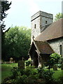
St Martin, Wootton
Looking West across the graveyard
Image: © Chris Shaw
Taken: 13 Aug 2006
0.02 miles

3
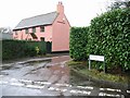
Salmon pink house on Denton Lane, Wootton
Image: © Nick Smith
Taken: 11 Feb 2007
0.03 miles
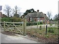
4

Interesting flint and brick house, Wootton
Image: © Nick Smith
Taken: 10 Mar 2007
0.05 miles
6
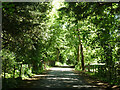
Wootton Lane, Wootton
The church is up on the left.
Image: © Robin Webster
Taken: 4 Jun 2015
0.08 miles
7
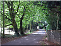
Wootton Lane
Beside Church of St Martin, Wootton.
Image: © Oast House Archive
Taken: 17 Jul 2010
0.08 miles
8
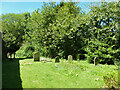
Churchyard, Wootton
The bit north of the church in the small yard.
Image: © Robin Webster
Taken: 4 Jun 2015
0.08 miles
9
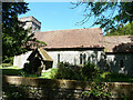
Wootton church
St. Martin's is a grade II*(star) listed building, basically 13th century.
Image: © Robin Webster
Taken: 4 Jun 2015
0.09 miles
10
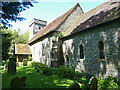
Wootton church
St. Martin's is a grade II*(star) listed building, basically 13th century.
Image: © Robin Webster
Taken: 4 Jun 2015
0.09 miles