IMAGES TAKEN NEAR TO
Denton, CANTERBURY, CT4 6RG
Introduction
This page details the photographs taken nearby to CT4 6RG by members of the Geograph project.
The Geograph project started in 2005 with the aim of publishing, organising and preserving representative images for every square kilometre of Great Britain, Ireland and the Isle of Man.

There are currently over 7.5m images from over14,400 individuals and you can help contribute to the project by visiting https://www.geograph.org.uk
Image Map
Images are licensed for reuse under creativecommons.org/licenses/by-sa/2.0
Notes
- Clicking on the map will re-center to the selected point.
- The higher the marker number, the further away the image location is from the centre of the postcode.
Image Listing (19 Images Found)
Images are licensed for reuse under creativecommons.org/licenses/by-sa/2.0
Image
Details
Distance
1
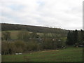
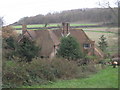
Tappington Hall Farm
As seen from the byway from Snode Hill to Gettridge Farm.
In the background is Denton Wood.
Image: © David Anstiss
Taken: 12 Dec 2010
0.05 miles
2
Footpath junction on a byway near Tappington Hall
A byway from Snode Hill leads straight on towards Gettridge Farm.
A footpath heads left along an access track to Tappington Hall and farm, before heading to the A260 Canterbury Road. It also heads right towards Snode Hill near Snodehill Farm.
Image: © David Anstiss
Taken: 12 Dec 2010
0.10 miles
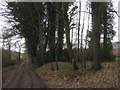
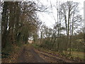
3
Byway to Tappington Hall
A byway/ farm track leads from Reece Lane, past Rakeshole Farm towards Gettridge Farm, then a farm road leads towards Tappington Hall near Snode Hill.
Image: © David Anstiss
Taken: 12 Dec 2010
0.10 miles
4
Tappington Hall Farm, Denton
A working farm, looking from the A260, Canterbury Road.
Image: © Oast House Archive
Taken: 17 Jul 2010
0.11 miles
5
Tappington Hall
Near Snode Hill. Denton Wood is in the background.
Image: © David Anstiss
Taken: 12 Dec 2010
0.11 miles
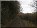
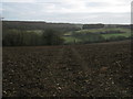
6
Byway to Snode Hill
This farm road leads from Gettridge Farm past Tappington Hall.
Image: © David Anstiss
Taken: 12 Dec 2010
0.12 miles
7
Footpath to Tappington Hall
A footpath leads from Snode Hill across a field, then over a byway near the Hall, then the path leads to the A260 Canterbury Road.
Denton Wood is in the background.
Image: © David Anstiss
Taken: 12 Dec 2010
0.12 miles
9
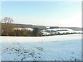
Footpath to Tappington Hall
As defined by the footprints through the snow. It looks quite different in May Image
Image: © John Baker
Taken: 11 Feb 2012
0.17 miles
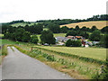
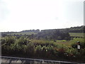
10
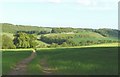
Footpath to Tappington Hall
Looking across the valley towards Denton Wood on the far hillside.
Image: © John Baker
Taken: 19 May 2009
0.18 miles