IMAGES TAKEN NEAR TO
Church Lane, CANTERBURY, CT4 6QS
Introduction
This page details the photographs taken nearby to Church Lane, CT4 6QS by members of the Geograph project.
The Geograph project started in 2005 with the aim of publishing, organising and preserving representative images for every square kilometre of Great Britain, Ireland and the Isle of Man.

There are currently over 7.5m images from over14,400 individuals and you can help contribute to the project by visiting https://www.geograph.org.uk
Image Map
Images are licensed for reuse under creativecommons.org/licenses/by-sa/2.0
Notes
- Clicking on the map will re-center to the selected point.
- The higher the marker number, the further away the image location is from the centre of the postcode.
Image Listing (12 Images Found)
Images are licensed for reuse under creativecommons.org/licenses/by-sa/2.0
Image
Details
Distance
1
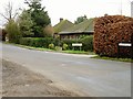
Junction of Gravel Castle Road and Church Lane
Image: © Nick Smith
Taken: 4 Feb 2007
0.05 miles
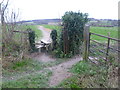
2
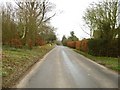
View along Church Lane towards Gravel Castle Road
Junction just beyond the grit box.
Image: © Nick Smith
Taken: 4 Feb 2007
0.09 miles
3
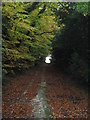
Bridleway near Thatched Cottage
This bridleway leads from Gravel Castle Road up towards the A260 Canterbury Road.
Image: © David Anstiss
Taken: 31 Oct 2010
0.09 miles
4
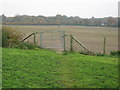
Bridle gate near Thatched Cottage
On a bridleway from Gravel Castle Road (beside the cottage) up towards the A260 Canterbury Road.
Image: © David Anstiss
Taken: 31 Oct 2010
0.15 miles
5
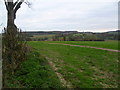
Footpath past Gravel Castle
This path is just south of Barham Church and leads downhill to Gravel Castle Road. The view looks towards Walderchain Wood in the distance.
Image: © Marathon
Taken: 7 Dec 2013
0.15 miles
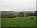
6
View from the Street
Looking over east Derringstone towards Walderchain Wood (in the background).
Image: © David Anstiss
Taken: 31 Oct 2010
0.15 miles
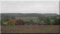
7
View of the valley towards Breach
As seen from a bridleway from Gravel Castle Road towards the A260 Canterbury Road. Walderchain Wood is in the background on the left.
Image: © David Anstiss
Taken: 31 Oct 2010
0.17 miles
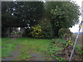
8
St. John the Baptist Cemetery
On the Street, east of the church.
Image: © David Anstiss
Taken: 31 Oct 2010
0.17 miles
9
Footpath past Gravel Castle
This path is just south of Barham Church and after passing the churchyard extension passes Gravel castle on the left just ahead before leading downhill to Gravel Castle Road. The view looks towards Walderchain Wood on the horizon.
Image: © Marathon
Taken: 7 Dec 2013
0.18 miles
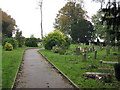
10
Lych Gate near St. John the Baptist Church Cemetery
This roofed gate leads into the cemetery to the east of the church.
The footpath on the right leads past the cemetery towards Gravel Castle Road.
Image: © David Anstiss
Taken: 31 Oct 2010
0.20 miles