IMAGES TAKEN NEAR TO
North Elham, CANTERBURY, CT4 6NW
Introduction
This page details the photographs taken nearby to North Elham, CT4 6NW by members of the Geograph project.
The Geograph project started in 2005 with the aim of publishing, organising and preserving representative images for every square kilometre of Great Britain, Ireland and the Isle of Man.

There are currently over 7.5m images from over14,400 individuals and you can help contribute to the project by visiting https://www.geograph.org.uk
Image Map
Images are licensed for reuse under creativecommons.org/licenses/by-sa/2.0
Notes
- Clicking on the map will re-center to the selected point.
- The higher the marker number, the further away the image location is from the centre of the postcode.
Image Listing (5 Images Found)
Images are licensed for reuse under creativecommons.org/licenses/by-sa/2.0
Image
Details
Distance
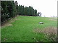
2
Lane towards Denton
Bedlam Wood to the left, Knoll Wood on the right.
Image: © Robin Webster
Taken: 2 Sep 2017
0.07 miles
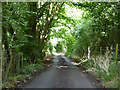
4
Red campion in a hedgerow
The footpath here passes close to Knoll Wood which is just off to the left.
Image: © Marathon
Taken: 27 May 2015
0.16 miles
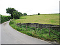
5

Cow parsley in a hedgerow
The footpath here passes close to Knoll Wood which is just off to the left.
Image: © Marathon
Taken: 27 May 2015
0.17 miles