IMAGES TAKEN NEAR TO
Holly Hill, CANTERBURY, CT4 6NH
Introduction
This page details the photographs taken nearby to Holly Hill, CT4 6NH by members of the Geograph project.
The Geograph project started in 2005 with the aim of publishing, organising and preserving representative images for every square kilometre of Great Britain, Ireland and the Isle of Man.

There are currently over 7.5m images from over14,400 individuals and you can help contribute to the project by visiting https://www.geograph.org.uk
Image Map
Images are licensed for reuse under creativecommons.org/licenses/by-sa/2.0
Notes
- Clicking on the map will re-center to the selected point.
- The higher the marker number, the further away the image location is from the centre of the postcode.
Image Listing (60 Images Found)
Images are licensed for reuse under creativecommons.org/licenses/by-sa/2.0
Image
Details
Distance
1
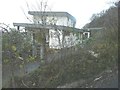
The Arc
Viewed from below it looks very out of place in an area of outstanding natural beauty. Planning permission has been approved, with conditions, by Folkestone and Hythe District Council under application number Y00/0701/SH for the “erection of replacement dwelling”. It appears that the site was previously occupied by a mobile home.
Image: © John Baker
Taken: 25 Nov 2012
0.00 miles
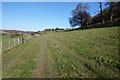
2
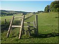
Unused stile on the Elham Valley Way near North Elham
The long distance path heads from the hamlet near Elham, along the fenceline towards Hall Downs and onwards to Wingmore Court Farm.
The Elham Valley is in the background.
Image: © David Anstiss
Taken: 18 Jul 2010
0.04 miles
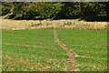
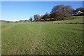
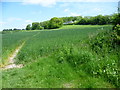
7
Elham Valley Way to North Elham
The long distance path leads from Wingmore along the downs on the Elham Valley.
It then heads to a few houses on a lane (North Elham near Elham).
Image: © David Anstiss
Taken: 9 Jan 2011
0.08 miles
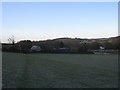
9
The Elham Valley Way at North Elham
The Elham Valley Way which connects Hythe to Canterbury follows the eastern slope of the valley here between North Elham and Wingmore. The modern house up ahead has impressive views across the valley. Full details of the Elham Valley Way can be seen at http://www.elham.co.uk/valley/Leaflets/elhamvalley-way.pdf
Image: © Marathon
Taken: 27 May 2015
0.08 miles
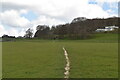
10
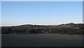
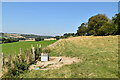
View of Elham
As seen from the Elham Valley Way on the Elham Valley Downs.
Looking towards North Elham (in the foreground) and the bigger village behind.
Image: © David Anstiss
Taken: 9 Jan 2011
0.08 miles