IMAGES TAKEN NEAR TO
Bladbean, CANTERBURY, CT4 6LY
Introduction
This page details the photographs taken nearby to CT4 6LY by members of the Geograph project.
The Geograph project started in 2005 with the aim of publishing, organising and preserving representative images for every square kilometre of Great Britain, Ireland and the Isle of Man.

There are currently over 7.5m images from over14,400 individuals and you can help contribute to the project by visiting https://www.geograph.org.uk
Image Map (Loading...)


Getting Data...Please wait
Leaflet Map data © OpenStreetMap
Images are licensed for reuse under creativecommons.org/licenses/by-sa/2.0
Notes
- Clicking on the map will re-center to the selected point.
- The higher the marker number, the further away the image location is from the centre of the postcode.
Image Listing (7 Images Found)
Images are licensed for reuse under creativecommons.org/licenses/by-sa/2.0
Image
Details
Distance
1
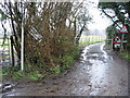
Dane Farm, Covet Lane
The farm is north of Bladbean. Covet Lane runs between Covert Wood on the right and Covet Wood on the left.
Image: © pam fray
Taken: 13 Apr 2016
0.04 miles
2
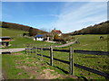
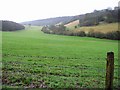
House in a valley
Covert Wood is beyond.
Image: © Robin Webster
Taken: 2 Sep 2017
0.06 miles
4
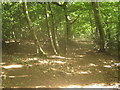
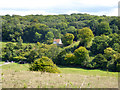
Footpath junction in Covert Wood
A footpath from Greenhills (road) leads through the large wood and then straight on towards Charcoal Farm. Another path heads right to Dane Farm, or left to a lane between Bladbean Farm and South Barham Farm.
Image: © David Anstiss
Taken: 18 Jul 2010
0.16 miles
6
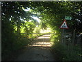
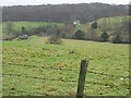
Number 3 Gate
This gated track leads to Dane Farm. The footpath on the right leads to Covert Wood.
Image: © David Anstiss
Taken: 18 Jul 2010
0.23 miles