IMAGES TAKEN NEAR TO
Wingmore, Elham, CANTERBURY, CT4 6LS
Introduction
This page details the photographs taken nearby to CT4 6LS by members of the Geograph project.
The Geograph project started in 2005 with the aim of publishing, organising and preserving representative images for every square kilometre of Great Britain, Ireland and the Isle of Man.

There are currently over 7.5m images from over14,400 individuals and you can help contribute to the project by visiting https://www.geograph.org.uk
Image Map
Images are licensed for reuse under creativecommons.org/licenses/by-sa/2.0
Notes
- Clicking on the map will re-center to the selected point.
- The higher the marker number, the further away the image location is from the centre of the postcode.
Image Listing (42 Images Found)
Images are licensed for reuse under creativecommons.org/licenses/by-sa/2.0
Image
Details
Distance
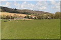
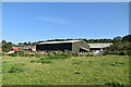
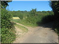
1
Wingmore Court Farm
Taken from the Elham Valley Way.
Image: © David Kemp
Taken: 17 Mar 2007
0.03 miles
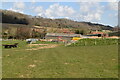
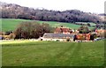
3
Unused stile on Elham Valley Way near Wingmore Court Farm
The long distance path heads up Oxroad, from the Elham Valley Road, past the farm. Then it heads left (via an unused stile) up towards Thomas Acre Wood.
Image: © David Anstiss
Taken: 18 Jul 2010
0.05 miles