IMAGES TAKEN NEAR TO
Greenhills, CANTERBURY, CT4 6JY
Introduction
This page details the photographs taken nearby to Greenhills, CT4 6JY by members of the Geograph project.
The Geograph project started in 2005 with the aim of publishing, organising and preserving representative images for every square kilometre of Great Britain, Ireland and the Isle of Man.

There are currently over 7.5m images from over14,400 individuals and you can help contribute to the project by visiting https://www.geograph.org.uk
Image Map
Images are licensed for reuse under creativecommons.org/licenses/by-sa/2.0
Notes
- Clicking on the map will re-center to the selected point.
- The higher the marker number, the further away the image location is from the centre of the postcode.
Image Listing (15 Images Found)
Images are licensed for reuse under creativecommons.org/licenses/by-sa/2.0
Image
Details
Distance
4
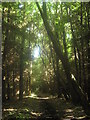
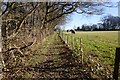
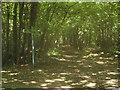
Bridleway in Covert Wood
This bridleway leads from Greenhills (road) toward Derringstone (via Sussex Farm). It leads through a coniferous part of the wood.
Image: © David Anstiss
Taken: 18 Jul 2010
0.13 miles
5
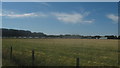
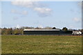
Pig sheds near Ham Farm
As seen from the bridleway leading from Deerringstone.
Image: © David Anstiss
Taken: 18 Jul 2010
0.15 miles
9
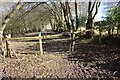
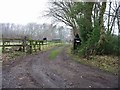
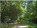
Bridleway junction in Covert Wood
A bridleway from Covet Lane, leads past Duskin Farm and then over Greenhills (road), then it divides. The path in the middle leads towards Derringstone (via Sussex Farm). The track on the right leads through the centre of the wood towards Hillhouse Farm, Bladbean.
Note; compare with Image
Image: © David Anstiss
Taken: 18 Jul 2010
0.19 miles
10
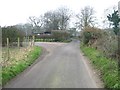
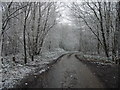
Access track into Covert Wood
This track leads from Greenhills Southwards into the wood.
Image: © David Anstiss
Taken: 18 Jul 2010
0.21 miles