IMAGES TAKEN NEAR TO
Bonny Bush Hill, CANTERBURY, CT4 6HT
Introduction
This page details the photographs taken nearby to Bonny Bush Hill, CT4 6HT by members of the Geograph project.
The Geograph project started in 2005 with the aim of publishing, organising and preserving representative images for every square kilometre of Great Britain, Ireland and the Isle of Man.

There are currently over 7.5m images from over14,400 individuals and you can help contribute to the project by visiting https://www.geograph.org.uk
Image Map
Images are licensed for reuse under creativecommons.org/licenses/by-sa/2.0
Notes
- Clicking on the map will re-center to the selected point.
- The higher the marker number, the further away the image location is from the centre of the postcode.
Image Listing (87 Images Found)
Images are licensed for reuse under creativecommons.org/licenses/by-sa/2.0
Image
Details
Distance
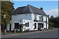
1
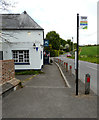
The Black Robin, Valley Road
The grade II 18th or early 19th century public house was temporarily closed due to the coronavirus pandemic https://britishlistedbuildings.co.uk/101049090-black-robin-public-house-kingston#.Xtfva_5Ybcc The road, where the car was parked, is Black Robin Lane. Buses stop here every two hours.
Image: © John Baker
Taken: 13 May 2020
0.03 miles
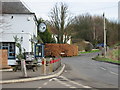
3
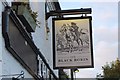
Black Robin Inn sign, Kingston
The pub dates back to 1741 and according to legend, Black Robin was a notorious highwayman who eventually met his end on the gallows at Barham Cross Roads. There is also a connection with smugglers who sold their goods tax-free here. See the pub's website http://www.theblackrobinpub.com/the-legend-of-the-black-robin.html for more on the legend of the Black Robin.
Image: © Jim Barton
Taken: 26 Sep 2015
0.03 miles
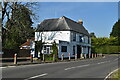
4
The Black Robin
Public house on the road to Bridge.
Image: © Jim Barton
Taken: 26 Sep 2015
0.03 miles

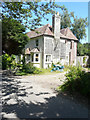
9
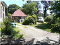
Land adjoining The Old Forge, Church Lane
Planning permission has been granted by Canterbury City Council under application number CA//18/00616 for a “proposed detached two-storey dwelling”.
The contractors had just started to clear the land, where the van is parked. This is a view of Image
Image: © John Baker
Taken: 3 Jul 2019
0.05 miles