IMAGES TAKEN NEAR TO
Dover Road, CANTERBURY, CT4 6HN
Introduction
This page details the photographs taken nearby to Dover Road, CT4 6HN by members of the Geograph project.
The Geograph project started in 2005 with the aim of publishing, organising and preserving representative images for every square kilometre of Great Britain, Ireland and the Isle of Man.

There are currently over 7.5m images from over14,400 individuals and you can help contribute to the project by visiting https://www.geograph.org.uk
Image Map (Loading...)


Getting Data...Please wait
Leaflet Map data © OpenStreetMap
Images are licensed for reuse under creativecommons.org/licenses/by-sa/2.0
Notes
- Clicking on the map will re-center to the selected point.
- The higher the marker number, the further away the image location is from the centre of the postcode.
Image Listing (24 Images Found)
Images are licensed for reuse under creativecommons.org/licenses/by-sa/2.0
Image
Details
Distance
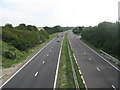
2
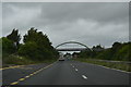
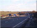
A2 Dover Road to Canterbury
As seen from Image
This dual carriageway leads from Dover to Canterbury and onwards to the M2 Junction 7.
In the background on the left is the junction with Black Robin Lane (leading to Kingston).
Image: © David Anstiss
Taken: 5 Sep 2010
0.05 miles
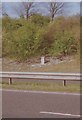
3
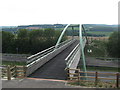
New Bridleway bridge over the A2 Dover Road
This bridge over the dual carriageway between Dover and Canterbury has recently been built. It connects a bridleway from Adisham with another leading to Kingston. Either side of the bridge are two new cycle paths.
See Image which shows the bridge being constructed and the two new cycle paths beside the road.
Image: © David Anstiss
Taken: 5 Sep 2010
0.08 miles
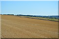
4
Cyclepath near the new bridleway bridge over the A2 Dover Road
This new cyclepath leads from the lane towards Gypsy Cottage to a lane to Windmill Cottage.
The A2 Dual carriageway is behind the trees on the left.
Image: © David Anstiss
Taken: 5 Sep 2010
0.09 miles
5
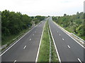
A2 Dover Road leading towards Dover
As seen from Image
This dual carriageway leads from the M2 Junction 7, past Canterbury and onwards towards Dover.
Image: © David Anstiss
Taken: 5 Sep 2010
0.10 miles
6
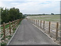
View from the new bridge on the A2
Looking southwards from the cyclepath beside the bridge over the dual carriageway.
Image: © David Anstiss
Taken: 5 Sep 2010
0.10 miles
8
Old Milestone by the A2, Dover Road, Barham parish
Carved stone post by the A2, in parish of BARHAM (CANTERBURY District), Dover Road, North of Old Elmstead Lane, on grass embankment, above Eastbound carriageway, on East side of road. Dover Road stone, erected by the Canterbury & Barham turnpike trust in the 19th century.
Inscription reads:-
: (DOVER / 10) : : CANTERBURY / 5 / LONDON / 61 :
Milestone Society National ID: KE_LD61.
Image: © C Woodward
Taken: 26 Apr 2008
0.15 miles
10
A2 Dual Carriageway heading towards Dover
This busy dual carriageway leads from the M2 towards Dover (and more importantly Dover Docks!). Seen from a bridleway from Bonny Bush Lane. In the background a bridge is being built, presumably a bridleway bridge, that connects the Bonny Bush Lane bridleway with another bridleway heading towards Pit Wood and Adisham.
See Image
Image: © David Anstiss
Taken: 30 Jan 2010
0.16 miles