IMAGES TAKEN NEAR TO
Dennehill, CANTERBURY, CT4 6HD
Introduction
This page details the photographs taken nearby to Dennehill, CT4 6HD by members of the Geograph project.
The Geograph project started in 2005 with the aim of publishing, organising and preserving representative images for every square kilometre of Great Britain, Ireland and the Isle of Man.

There are currently over 7.5m images from over14,400 individuals and you can help contribute to the project by visiting https://www.geograph.org.uk
Image Map
Images are licensed for reuse under creativecommons.org/licenses/by-sa/2.0
Notes
- Clicking on the map will re-center to the selected point.
- The higher the marker number, the further away the image location is from the centre of the postcode.
Image Listing (8 Images Found)
Images are licensed for reuse under creativecommons.org/licenses/by-sa/2.0
Image
Details
Distance
1

Denne Hill Farm
Denne Hill Farmhouse is at the back.
Image: © David Anstiss
Taken: 31 Oct 2010
0.02 miles
2

Denne Hill Farm Barn
Being used as Denne Hill Business Centre.
See http://www.dennehillfarms.co.uk/ for more detail about the farm.
Image: © David Anstiss
Taken: 31 Oct 2010
0.03 miles
3

Footpath towards Wick Lane
This farm track leads from Denne Hill Farm towards the lane near Woolage Green.
Image: © David Anstiss
Taken: 31 Oct 2010
0.07 miles
4
Access road towards Denne Hill
This road leads from to the house in the Denne Hill Farm.
On the left is a wall around the farm. In the background is Gardner's Cottage (in the wall).
Image: © David Anstiss
Taken: 31 Oct 2010
0.10 miles
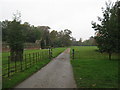
5

Bridleway and footpath junction near Denne Hill Farm
A bridleway (and farm access road) leads from the farm towards the lane between Adisham Road and Woolage Village. A footpath (also farmtrack) leads right through the farm towards Wick Lane.
Image: © David Anstiss
Taken: 31 Oct 2010
0.10 miles
6

Farm track to Denne Hill Farm
This track is used by a footpath from Wick Lane leading towards the farm and a bridleway.
Image: © David Anstiss
Taken: 31 Oct 2010
0.11 miles
7
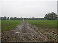
Farm track near Denne Hill Farm
This track leads across a field from the bridleway beside the farm.
Image: © David Anstiss
Taken: 31 Oct 2010
0.18 miles
8
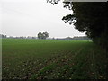
Bridleway to Denne Hill Farm
This bridleway from the A260 Canterbury Road past the farm towards the lane between Adisham Road and Woolage Village.
Image: © David Anstiss
Taken: 31 Oct 2010
0.23 miles