IMAGES TAKEN NEAR TO
Upper Hardres, CANTERBURY, CT4 6EW
Introduction
This page details the photographs taken nearby to CT4 6EW by members of the Geograph project.
The Geograph project started in 2005 with the aim of publishing, organising and preserving representative images for every square kilometre of Great Britain, Ireland and the Isle of Man.

There are currently over 7.5m images from over14,400 individuals and you can help contribute to the project by visiting https://www.geograph.org.uk
Image Map
Images are licensed for reuse under creativecommons.org/licenses/by-sa/2.0
Notes
- Clicking on the map will re-center to the selected point.
- The higher the marker number, the further away the image location is from the centre of the postcode.
Image Listing (62 Images Found)
Images are licensed for reuse under creativecommons.org/licenses/by-sa/2.0
Image
Details
Distance
5
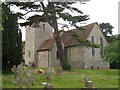
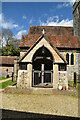
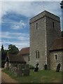
Church of St Peter and St Paul, Upper Hardres
Grade I listed https://historicengland.org.uk/listing/the-list/list-entry/1045850 Norman church.
Image: © Oast House Archive
Taken: 24 Jun 2010
0.02 miles
6
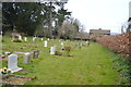
Churchyard, Church of St Peter and St Paul
Image: © N Chadwick
Taken: 2 Apr 2016
0.02 miles
7
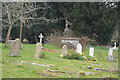
Churchyard, Church of St Peter and St Paul
Image: © N Chadwick
Taken: 2 Apr 2016
0.02 miles
8
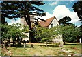
St. Peter & St. Paul Church, Upper Hardres
Image: © Roger Smith
Taken: 9 Jun 1997
0.03 miles
9
Church of St Peter and St Paul, Upper Hardres
Entrance to the Norman church and tower.
Image: © David Anstiss
Taken: 18 Jul 2010
0.03 miles
10
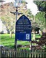
Notice board for St Peter and St Paul, Upper Hardres
Image: © Nick Smith
Taken: 17 Feb 2007
0.03 miles