IMAGES TAKEN NEAR TO
Lynsore Bottom, Upper Hardres, CANTERBURY, CT4 6EE
Introduction
This page details the photographs taken nearby to CT4 6EE by members of the Geograph project.
The Geograph project started in 2005 with the aim of publishing, organising and preserving representative images for every square kilometre of Great Britain, Ireland and the Isle of Man.

There are currently over 7.5m images from over14,400 individuals and you can help contribute to the project by visiting https://www.geograph.org.uk
Image Map
Images are licensed for reuse under creativecommons.org/licenses/by-sa/2.0
Notes
- Clicking on the map will re-center to the selected point.
- The higher the marker number, the further away the image location is from the centre of the postcode.
Image Listing (6 Images Found)
Images are licensed for reuse under creativecommons.org/licenses/by-sa/2.0
Image
Details
Distance
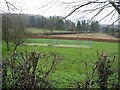
1
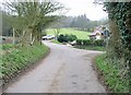
Pett Bottom Road junction near Lynsore Court
Image: © Nick Smith
Taken: 4 Feb 2007
0.02 miles
3
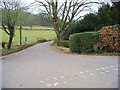
Road to Bossingham and entrance to Lynsore Court
Entrance by post box
Image: © Nick Smith
Taken: 4 Feb 2007
0.07 miles
4
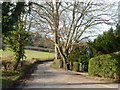
The way to Bossingham
Lynsore Court is on the right.
Image: © Robin Webster
Taken: 28 Dec 2015
0.07 miles
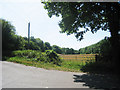
6
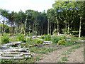
Coppiced area, Featherley Wood
The wood appears to be largely managed as coppice.
Image: © Robin Webster
Taken: 2 Sep 2017
0.23 miles