IMAGES TAKEN NEAR TO
Sandy Lane, CANTERBURY, CT4 6DS
Introduction
This page details the photographs taken nearby to Sandy Lane, CT4 6DS by members of the Geograph project.
The Geograph project started in 2005 with the aim of publishing, organising and preserving representative images for every square kilometre of Great Britain, Ireland and the Isle of Man.

There are currently over 7.5m images from over14,400 individuals and you can help contribute to the project by visiting https://www.geograph.org.uk
Image Map
Images are licensed for reuse under creativecommons.org/licenses/by-sa/2.0
Notes
- Clicking on the map will re-center to the selected point.
- The higher the marker number, the further away the image location is from the centre of the postcode.
Image Listing (4 Images Found)
Images are licensed for reuse under creativecommons.org/licenses/by-sa/2.0
Image
Details
Distance
1
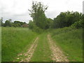
Bridleway to Eastleigh Court and Lower Courthope Farm
This bridleway leads from Stone Street, near Thorn Lane junction towards High Minnis.
Image: © David Anstiss
Taken: 20 Jun 2010
0.13 miles
2
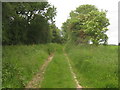
Bridleway to Stone Street
This track leads from High Minnis, past Lower Courthope Farm towards the B2068 near Thorn Lane.
Image: © David Anstiss
Taken: 20 Jun 2010
0.17 miles
3
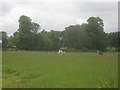
Llamas of Stone Hall
These animals originally from South America seem to be a new thing in farming these days.
Seen from a footpath from Stone Street towards Stelling Minnis.
Image: © David Anstiss
Taken: 20 Jun 2010
0.21 miles
4
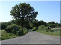
Dead End Road
This road leads to Eastleigh Court
Image: © Hywel Williams
Taken: 24 Jun 2006
0.21 miles