IMAGES TAKEN NEAR TO
Elham Valley Road, CANTERBURY, CT4 6DQ
Introduction
This page details the photographs taken nearby to Elham Valley Road, CT4 6DQ by members of the Geograph project.
The Geograph project started in 2005 with the aim of publishing, organising and preserving representative images for every square kilometre of Great Britain, Ireland and the Isle of Man.

There are currently over 7.5m images from over14,400 individuals and you can help contribute to the project by visiting https://www.geograph.org.uk
Image Map
Images are licensed for reuse under creativecommons.org/licenses/by-sa/2.0
Notes
- Clicking on the map will re-center to the selected point.
- The higher the marker number, the further away the image location is from the centre of the postcode.
Image Listing (26 Images Found)
Images are licensed for reuse under creativecommons.org/licenses/by-sa/2.0
Image
Details
Distance
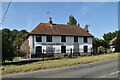
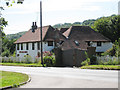
5
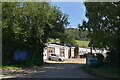
Dolls House Pub
South of Canterbury, Kent. The pub has lots of full size dolls inside, or at least had when we were there, in the late 1980's. There's also a vineyard next door! Not absolutely sure of the date, however.
Image: © David Chatterton
Taken: Unknown
0.07 miles
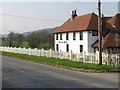
7
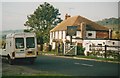
The Dolls House
Former pub and then restaurant at Breach.
Image: © Oast House Archive
Taken: 18 Jul 2010
0.08 miles