IMAGES TAKEN NEAR TO
Stone Street, CANTERBURY, CT4 6DL
Introduction
This page details the photographs taken nearby to Stone Street, CT4 6DL by members of the Geograph project.
The Geograph project started in 2005 with the aim of publishing, organising and preserving representative images for every square kilometre of Great Britain, Ireland and the Isle of Man.

There are currently over 7.5m images from over14,400 individuals and you can help contribute to the project by visiting https://www.geograph.org.uk
Image Map
Images are licensed for reuse under creativecommons.org/licenses/by-sa/2.0
Notes
- Clicking on the map will re-center to the selected point.
- The higher the marker number, the further away the image location is from the centre of the postcode.
Image Listing (2 Images Found)
Images are licensed for reuse under creativecommons.org/licenses/by-sa/2.0
Image
Details
Distance
1
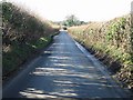
Stone Street
Taken from the edge of TR1343, looking south down Stone Street, this Roman road runs from Canterbury to the North (behind the photo) down towards Romney Marsh. The woodland to the left is CROW land and blue bells flower through the wood and are visible from the road
Image: © Adam Hincks
Taken: 14 Apr 2007
0.02 miles