IMAGES TAKEN NEAR TO
Stone Street, CANTERBURY, CT4 6DA
Introduction
This page details the photographs taken nearby to Stone Street, CT4 6DA by members of the Geograph project.
The Geograph project started in 2005 with the aim of publishing, organising and preserving representative images for every square kilometre of Great Britain, Ireland and the Isle of Man.

There are currently over 7.5m images from over14,400 individuals and you can help contribute to the project by visiting https://www.geograph.org.uk
Image Map
Images are licensed for reuse under creativecommons.org/licenses/by-sa/2.0
Notes
- Clicking on the map will re-center to the selected point.
- The higher the marker number, the further away the image location is from the centre of the postcode.
Image Listing (17 Images Found)
Images are licensed for reuse under creativecommons.org/licenses/by-sa/2.0
Image
Details
Distance
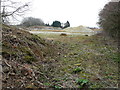
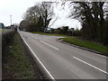
1

B2068 Stone Street towards Canterbury
The Roman road nears an area with several turnings.
Image: © Robin Webster
Taken: 8 Jul 2018
0.01 miles
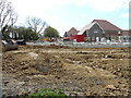
2

Stonegate Business Park, Stone Street
Planning permission was approved, with conditions, by Folkestone and Hythe District Council under application number Y15/1292/SH for the “demolition of buildings and structures, remediation of land and the erection of 30 houses and two B1 office units of 465m2 floor area, plus the closure of existing access to Stone Street and creation of new access to Thorn Lane”.
This image shows the entrance to Image in March 2018 and how the hoarding has been replaced by a more descriptive advertisement by Pentland Homes.
Image: © John Baker
Taken: 7 Oct 2018
0.08 miles
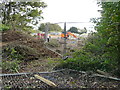
3

Closed entrance to Stonegate Business Park
A bank of earth has been deposited across the entrance to Image and any traffic wishing to access the site now has to travel along Image, take the next left into Thorn Lane and then, after a few yards, the road into Image
Image: © John Baker
Taken: 25 Apr 2021
0.08 miles
4

Stonegate Business Park, Stone Street
Planning permission was approved, with conditions, by Folkestone and Hythe District Council under application number Y15/1292/SH for the “demolition of buildings and structures, remediation of land and the erection of 30 houses and two B1 office units of 465m2 floor area, plus the closure of existing access to Stone Street and creation of new access to Thorn Lane”.
This image shows the main entrance into the site from Stone Street.
Image: © John Baker
Taken: 25 Mar 2018
0.09 miles
5
Stonegate Business Park, Stone Street
Planning permission was approved, with conditions, by Folkestone and Hythe District Council under application number Y15/1292/SH for the “demolition of buildings and structures, remediation of land and the erection of 30 houses and two B1 office units of 465m2 floor area, plus the closure of existing access to Stone Street and creation of new access to Thorn Lane”.
This image shows where the access to/from Thorn Lane will be located.
Image: © John Baker
Taken: 25 Mar 2018
0.11 miles
6
Stonegate Business Park, Stone Street
Planning permission was approved, with conditions, by Folkestone and Hythe District Council under application number Y15/1292/SH for the “demolition of buildings and structures, remediation of land and the erection of 30 houses and two B1 office units of 465m2 floor area, plus the closure of existing access to Stone Street and creation of new access to Thorn Lane”.
This image shows where the access to/from Thorn Lane will be located and how this view of Image looked in March 2018.
Image: © John Baker
Taken: 7 Oct 2018
0.11 miles
7
Stone Street
This used to be the entrance to Image but it has been closed due to a reorganisation of the next junction. This means vehicles can now reach the business park via Thorn Lane.
Image: © John Baker
Taken: 25 Apr 2021
0.12 miles
8
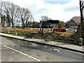
Radstone Gate development
Planning permission was approved, with conditions, by Folkestone and Hythe District Council under application number Y15/1292/SH for the “demolition of buildings and structures, remediation of land and the erection of 30 houses and two B1 office units of 465m2 floor area, plus the closure of existing access to Stone Street and creation of new access to Thorn Lane”.
The road in the foreground is Thorn Lane.
Image: © John Baker
Taken: 25 Apr 2021
0.12 miles
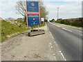
9
Stonegate Business Park, Stone Street
Planning permission was approved, with conditions, by Folkestone and Hythe District Council under application number Y15/1292/SH for the “demolition of buildings and structures, remediation of land and the erection of 30 houses and two B1 office units of 465m2 floor area, plus the closure of existing access to Stone Street and creation of new access to Thorn Lane”.
This image shows the information board depicting Stonegate Business Park.
A resident from Stelling Minnis told me that the road junction at this location is to be redesigned to reduce the speed of traffic on Stone Street and make it safer for vehicles turning into Thorn Lane.
Image: © John Baker
Taken: 25 Mar 2018
0.12 miles
10
Radstone Gate development
Planning permission was approved, with conditions, by Folkestone and Hythe District Council under application number Y15/1292/SH for the “demolition of buildings and structures, remediation of land and the erection of 30 houses and two B1 office units of 465m2 floor area, plus the closure of existing access to Stone Street and creation of new access to Thorn Lane”.
Image: © John Baker
Taken: 25 Apr 2021
0.12 miles