IMAGES TAKEN NEAR TO
North Leigh, CANTERBURY, CT4 6BX
Introduction
This page details the photographs taken nearby to North Leigh, CT4 6BX by members of the Geograph project.
The Geograph project started in 2005 with the aim of publishing, organising and preserving representative images for every square kilometre of Great Britain, Ireland and the Isle of Man.

There are currently over 7.5m images from over14,400 individuals and you can help contribute to the project by visiting https://www.geograph.org.uk
Image Map
Images are licensed for reuse under creativecommons.org/licenses/by-sa/2.0
Notes
- Clicking on the map will re-center to the selected point.
- The higher the marker number, the further away the image location is from the centre of the postcode.
Image Listing (6 Images Found)
Images are licensed for reuse under creativecommons.org/licenses/by-sa/2.0
Image
Details
Distance
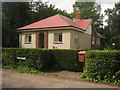
1
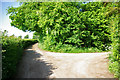
Lane junction near North Leigh
The through route turns right. Straight on is a short approach to premises with no public continuation.
Image: © Robin Webster
Taken: 22 May 2007
0.04 miles
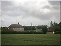
2
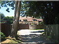
Leigh Barton Farm
Grade II listed timber framed house.
Image: © Oast House Archive
Taken: 10 Jul 2010
0.05 miles
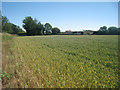
4
Farm road to Little North Leigh Farm
This access road leads of Thorn Lane towards the farm and Thorn Farm.
The footpath leads past the farm towards Spong Farm near Spong Wood through Edards Wood.
Image: © David Anstiss
Taken: 20 Jun 2010
0.19 miles
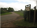
5
Little North Leigh Farm
As seen from Thorn Lane.
In the background is Thorn Farm Wind Turbine.
Image: © David Anstiss
Taken: 20 Jun 2010
0.22 miles
6
Westcroft Farm
On Image
Trees in the background are part of Yockletts Bank Nature Reserve.
Image: © David Anstiss
Taken: 20 Jun 2010
0.24 miles