IMAGES TAKEN NEAR TO
Split Lane, CANTERBURY, CT4 6BA
Introduction
This page details the photographs taken nearby to Split Lane, CT4 6BA by members of the Geograph project.
The Geograph project started in 2005 with the aim of publishing, organising and preserving representative images for every square kilometre of Great Britain, Ireland and the Isle of Man.

There are currently over 7.5m images from over14,400 individuals and you can help contribute to the project by visiting https://www.geograph.org.uk
Image Map
Images are licensed for reuse under creativecommons.org/licenses/by-sa/2.0
Notes
- Clicking on the map will re-center to the selected point.
- The higher the marker number, the further away the image location is from the centre of the postcode.
Image Listing (4 Images Found)
Images are licensed for reuse under creativecommons.org/licenses/by-sa/2.0
Image
Details
Distance
1

High Chimney Farm
As seen from a footpath from Cherry Garden Farm towards Attchester Wood.
Image: © David Anstiss
Taken: 18 Jul 2010
0.01 miles
2
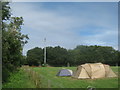
Mobile Phone Mast and tent
Mast near High Chimney Farm, tent used for a family holiday purposes.
Image: © David Anstiss
Taken: 18 Jul 2010
0.06 miles
3

Cherry Garden Farm
As seen from a footpath leading past the farm from Bossingham Road towards High Chimney Farm.
Image: © David Anstiss
Taken: 18 Jul 2010
0.19 miles
4

Cherry Garden Farm
Just visible, in the shade, is a gate on a footpath that passes through it and runs across the meadow to the right of the tree.
Image: © John Baker
Taken: 3 Aug 2014
0.20 miles