IMAGES TAKEN NEAR TO
Bossingham Road, CANTERBURY, CT4 6AZ
Introduction
This page details the photographs taken nearby to Bossingham Road, CT4 6AZ by members of the Geograph project.
The Geograph project started in 2005 with the aim of publishing, organising and preserving representative images for every square kilometre of Great Britain, Ireland and the Isle of Man.

There are currently over 7.5m images from over14,400 individuals and you can help contribute to the project by visiting https://www.geograph.org.uk
Image Map (Loading...)


Getting Data...Please wait
Leaflet Map data © OpenStreetMap
Images are licensed for reuse under creativecommons.org/licenses/by-sa/2.0
Notes
- Clicking on the map will re-center to the selected point.
- The higher the marker number, the further away the image location is from the centre of the postcode.
Image Listing (7 Images Found)
Images are licensed for reuse under creativecommons.org/licenses/by-sa/2.0
Image
Details
Distance
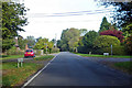
1

Stelling Minnis Common Information Board
On a path into the open land path near Bossingham.
The common is 124 acres (50 Hectares) is privately owned by the trustees of the estate of the late Lord Tomlin of Ash, and is one of the last remaining un-enlosed manorial commons in Kent.
Image: © David Anstiss
Taken: 18 Jul 2010
0.07 miles
4
Yew Tree Cottage, Split Lane
The house is a grade II listed building dating from the late 16th or 17th century
http://www.britishlistedbuildings.co.uk/en-441745-yew-tree-cottage-stelling-minnis-kent
Image: © John Baker
Taken: 3 Aug 2014
0.14 miles
5
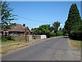
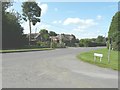
Bossingham Road towards Bossingham
The dead-end Split Lane on the right.
Image: © Robin Webster
Taken: 13 Oct 2018
0.15 miles
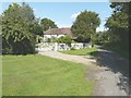
6
The Grange, Bossingham Road
Seen from Split Lane.
Image: © John Baker
Taken: 3 Aug 2014
0.15 miles
7

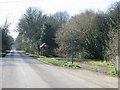
Bossingham Road
This long straight road runs past Stelling Minnis Common (on the left) towards Bossingham.
Compare with Image
Image: © David Anstiss
Taken: 18 Jul 2010
0.23 miles