IMAGES TAKEN NEAR TO
Richdore Road, CANTERBURY, CT4 5SH
Introduction
This page details the photographs taken nearby to Richdore Road, CT4 5SH by members of the Geograph project.
The Geograph project started in 2005 with the aim of publishing, organising and preserving representative images for every square kilometre of Great Britain, Ireland and the Isle of Man.

There are currently over 7.5m images from over14,400 individuals and you can help contribute to the project by visiting https://www.geograph.org.uk
Image Map
Images are licensed for reuse under creativecommons.org/licenses/by-sa/2.0
Notes
- Clicking on the map will re-center to the selected point.
- The higher the marker number, the further away the image location is from the centre of the postcode.
Image Listing (14 Images Found)
Images are licensed for reuse under creativecommons.org/licenses/by-sa/2.0
Image
Details
Distance
1
Waltham Village Hall
On Kake Street, from junction of Church Lane.
Image: © Oast House Archive
Taken: 10 Jul 2010
0.00 miles
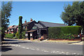
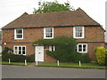
2
Was the Lord Nelson Public House, Waltham
Closed pub now converted into a private residence.
Image: © David Anstiss
Taken: 20 Jun 2010
0.03 miles
4
Waltham Village Sign
Small metal sign on the junction of Kake Street (on the left) and Church Lane (in front).
Image: © David Anstiss
Taken: 20 Jun 2010
0.04 miles
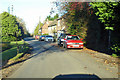
5
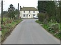
Looking SW along Kake Street to former pub
Image: © Nick Smith
Taken: 18 Feb 2007
0.05 miles
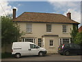
6
Kake Cottage
On Kake Street in Waltham village.
Image: © David Anstiss
Taken: 20 Jun 2010
0.08 miles
7
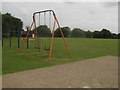
Waltham Village Park
Play park and recreational green beside Church Lane.
Image: © David Anstiss
Taken: 20 Jun 2010
0.10 miles
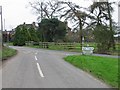
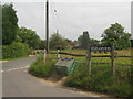
10
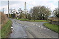
Junction of Richdore Road and Woods Hill
Image: © Julian P Guffogg
Taken: 30 Mar 2013
0.15 miles