IMAGES TAKEN NEAR TO
Waltham, CANTERBURY, CT4 5PZ
Introduction
This page details the photographs taken nearby to CT4 5PZ by members of the Geograph project.
The Geograph project started in 2005 with the aim of publishing, organising and preserving representative images for every square kilometre of Great Britain, Ireland and the Isle of Man.

There are currently over 7.5m images from over14,400 individuals and you can help contribute to the project by visiting https://www.geograph.org.uk
Image Map
Images are licensed for reuse under creativecommons.org/licenses/by-sa/2.0
Notes
- Clicking on the map will re-center to the selected point.
- The higher the marker number, the further away the image location is from the centre of the postcode.
Image Listing (28 Images Found)
Images are licensed for reuse under creativecommons.org/licenses/by-sa/2.0
Image
Details
Distance
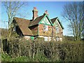
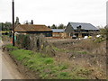
1
Yockletts Farm, near Waltham
Viewed from Duckpit Road looking towards Church Lane.
Image: © pam fray
Taken: 10 May 2022
0.03 miles
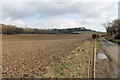
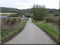
3

Junction of Church Lane with Duckpit Road
Image: © Nick Smith
Taken: 22 Feb 2009
0.05 miles
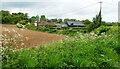
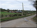
4
Fields off Duckpit Road
Yockletts Banks Woods on the left.
Image: © Julian P Guffogg
Taken: 30 Mar 2013
0.08 miles
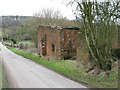
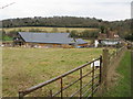
6

Yockletts Farm
Farmhouse now used as a luxury holiday home.
Image: © Oast House Archive
Taken: 10 Jul 2010
0.09 miles
9
Yockletts Farm on Church Lane
From the junction of Gogway and Duckpit Road.
Image: © Nick Smith
Taken: 22 Feb 2009
0.10 miles