IMAGES TAKEN NEAR TO
Lower Hardres, CANTERBURY, CT4 5PH
Introduction
This page details the photographs taken nearby to CT4 5PH by members of the Geograph project.
The Geograph project started in 2005 with the aim of publishing, organising and preserving representative images for every square kilometre of Great Britain, Ireland and the Isle of Man.

There are currently over 7.5m images from over14,400 individuals and you can help contribute to the project by visiting https://www.geograph.org.uk
Image Map
Images are licensed for reuse under creativecommons.org/licenses/by-sa/2.0
Notes
- Clicking on the map will re-center to the selected point.
- The higher the marker number, the further away the image location is from the centre of the postcode.
Image Listing (16 Images Found)
Images are licensed for reuse under creativecommons.org/licenses/by-sa/2.0
Image
Details
Distance


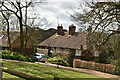
3
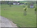
Little Catt's Farm
Grade II http://list.english-heritage.org.uk/resultsingle.aspx?uid=1336569 farmhouse, Mediaeval hall house, re-fronted in C18 as many were at that time. Presumed dovecot to left.
Image: © Oast House Archive
Taken: 24 Jun 2010
0.04 miles


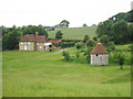
6
Little Catt's Farm
The sweeping view from the Catt's Wood Road takes in a curious oast-like building set on its own to the right of shot. Possibly a dove-cot, or just a folly?
Image: © Jonathan Billinger
Taken: 25 Apr 2007
0.05 miles