IMAGES TAKEN NEAR TO
Saxon Road, CANTERBURY, CT4 5LR
Introduction
This page details the photographs taken nearby to Saxon Road, CT4 5LR by members of the Geograph project.
The Geograph project started in 2005 with the aim of publishing, organising and preserving representative images for every square kilometre of Great Britain, Ireland and the Isle of Man.

There are currently over 7.5m images from over14,400 individuals and you can help contribute to the project by visiting https://www.geograph.org.uk
Image Map
Images are licensed for reuse under creativecommons.org/licenses/by-sa/2.0
Notes
- Clicking on the map will re-center to the selected point.
- The higher the marker number, the further away the image location is from the centre of the postcode.
Image Listing (191 Images Found)
Images are licensed for reuse under creativecommons.org/licenses/by-sa/2.0
Image
Details
Distance

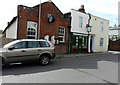
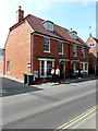
3
Looking west along the High Street
To where the premises, known as Woodlands, which is a business specialising in hair, beauty and holistic therapies http://www.woodlands-bridge.co.uk/ has had scaffolding erected on its frontage. It would appear that this is aid the repair of the parapet.
Image: © John Baker
Taken: 19 Apr 2015
0.04 miles
4
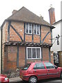
No. 42 Bridge High Street
Listed (and 'listing') building. Note the Sailing Boat lamp holder on the left.
Image: © David Anstiss
Taken: 26 Mar 2010
0.04 miles
5

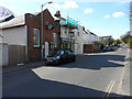
Rogers Garage, 36 High Street
It is now referred to as a Image
Image: © John Baker
Taken: 22 Sep 2013
0.04 miles
6
Woodlands, 26a, High Street, Bridge
Compared with Image but seen from a closer perspective, it appears that the shop’s frontage has been repainted. Woodlands is a business specialising in hair, beauty and holistic therapies http://www.woodlands-bridge.co.uk/
Image: © John Baker
Taken: 2 Aug 2015
0.04 miles
7
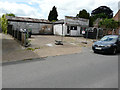
Former garage, 36, High Street
This used to be Image but it now appears to have ceased trading.
Image: © John Baker
Taken: 4 Jun 2017
0.04 miles
8
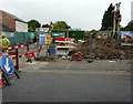
36, High Street
Planning permission has been granted by Canterbury City Council under application number CA//18/00860 for “proposed 3 two-storey dwellings with associated parking and access following demolition of existing buildings”.
This view shows the Image
Image: © John Baker
Taken: 4 Jun 2019
0.04 miles
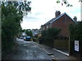
10
Semi-detached house, High Street
The left hand half has been named Farrington House while the other half has been named Union House. They were built on the site of a Image and this photo of Image shows their construction in June 2019.
Image: © John Baker
Taken: 16 Apr 2020
0.05 miles