IMAGES TAKEN NEAR TO
Bridge, CANTERBURY, CT4 5HJ
Introduction
This page details the photographs taken nearby to CT4 5HJ by members of the Geograph project.
The Geograph project started in 2005 with the aim of publishing, organising and preserving representative images for every square kilometre of Great Britain, Ireland and the Isle of Man.

There are currently over 7.5m images from over14,400 individuals and you can help contribute to the project by visiting https://www.geograph.org.uk
Image Map
Images are licensed for reuse under creativecommons.org/licenses/by-sa/2.0
Notes
- Clicking on the map will re-center to the selected point.
- The higher the marker number, the further away the image location is from the centre of the postcode.
Image Listing (6 Images Found)
Images are licensed for reuse under creativecommons.org/licenses/by-sa/2.0
Image
Details
Distance
1
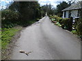
A lane passes Gipsy Cottage
This quiet lane comes to an abrupt and noisy end ahead where it meets the A2 dual carriageway.
Image: © Marathon
Taken: 5 Apr 2015
0.04 miles
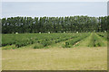
3
Blackcurrant bushes near the North Downs Way
Image: © Nick Smith
Taken: 30 Sep 2007
0.13 miles
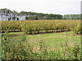
4
Fruit Field near Cold Harbour Farm
Image: © Oast House Archive
Taken: 18 Jul 2010
0.16 miles
5
Mobile Phone Towers beside Bramling Road
As seen from the North Downs Way.
Image: © David Anstiss
Taken: 5 Sep 2010
0.20 miles
6
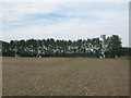
Looking towards Ileden Farm
This view is from a footpath between Gipsy Cottage and the North Downs Way. Ileden Farm is just visible to the left of the trees and Walk Wood is in the distance on the right.
Image: © Marathon
Taken: 5 Apr 2015
0.25 miles