IMAGES TAKEN NEAR TO
Bridge, CANTERBURY, CT4 5HH
Introduction
This page details the photographs taken nearby to CT4 5HH by members of the Geograph project.
The Geograph project started in 2005 with the aim of publishing, organising and preserving representative images for every square kilometre of Great Britain, Ireland and the Isle of Man.

There are currently over 7.5m images from over14,400 individuals and you can help contribute to the project by visiting https://www.geograph.org.uk
Image Map
Images are licensed for reuse under creativecommons.org/licenses/by-sa/2.0
Notes
- Clicking on the map will re-center to the selected point.
- The higher the marker number, the further away the image location is from the centre of the postcode.
Image Listing (11 Images Found)
Images are licensed for reuse under creativecommons.org/licenses/by-sa/2.0
Image
Details
Distance
1
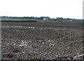
Land at Highland Court Farm, Coldharbour Lane
Planning permission was refused by Canterbury City Council under application number CA//18/01948 for a "hybrid planning application for mixed use development for leisure, commercial and tourism uses comprising: (1) A detailed planning application for a centre for sporting excellence (to include sports pitches, changing rooms, clubhouse and floodlights), business innovation centre, food and drinks hub and leisure hub; with access and associated highways works. (2) An outline planning application (with all matters reserved) for business uses, food and drinks hub, innovation centre, home farm centre, artisan offices, mixed use court and holiday homes; plus associated access, landscaping, parking and drainage infrastructure".
The development would not have reached as far as the corner of this muddy field but it would have been a blot on the landscape, which lies within an Area of Outstanding Natural Beauty.
Highland Court Farm Image is visible in the distance.
Image: © John Baker
Taken: 11 Nov 2018
0.12 miles
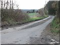
2
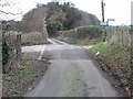
Junction of Coldharbour Lane and Brambling Road.
Image: © Nick Smith
Taken: 28 Jan 2007
0.13 miles
5
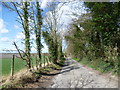
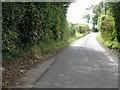
Lane near Cold Harbour Farm
This quiet lane reaches a junction just ahead and by turning left reaches either Bekesbourne or Patrixbourne.
Image: © Marathon
Taken: 5 Apr 2015
0.18 miles
7
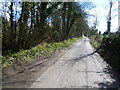
Lane towards Cold Harbour Farm
This quiet lane reaches a crossroads ahead and beyond passes Cold Harbour Farm before reaching the A2.
Image: © Marathon
Taken: 5 Apr 2015
0.19 miles
9
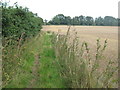
Bridleway to Bramling Road
This track leads from Keepers Hill Wood, through Highland Court Farm then it heads to the road (in the trees in the background).
Image: © David Anstiss
Taken: 5 Sep 2010
0.21 miles
10
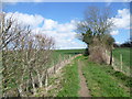
Path near Highland Court Farm
This path leads from Highland Court Farm through a narrow shaw ahead to reach a lane.
Image: © Marathon
Taken: 5 Apr 2015
0.22 miles