IMAGES TAKEN NEAR TO
Bramling Road, CANTERBURY, CT4 5HE
Introduction
This page details the photographs taken nearby to Bramling Road, CT4 5HE by members of the Geograph project.
The Geograph project started in 2005 with the aim of publishing, organising and preserving representative images for every square kilometre of Great Britain, Ireland and the Isle of Man.

There are currently over 7.5m images from over14,400 individuals and you can help contribute to the project by visiting https://www.geograph.org.uk
Image Map
Images are licensed for reuse under creativecommons.org/licenses/by-sa/2.0
Notes
- Clicking on the map will re-center to the selected point.
- The higher the marker number, the further away the image location is from the centre of the postcode.
Image Listing (7 Images Found)
Images are licensed for reuse under creativecommons.org/licenses/by-sa/2.0
Image
Details
Distance
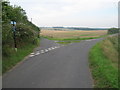
1
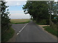
Road junction on Bramling Road
Bramling Road leads from the A2 Dover Road towards Bramling.
Shepherd's Close Road leads left towards Shepherd's Close Farm and onward to Patrixbourne.
A byway also heads right past Chota (house) towards Woodlands Wood.
Image: © David Anstiss
Taken: 5 Sep 2010
0.04 miles
2
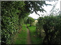
Byway to Woodlands Wood
This track leads from Bramling Road (near Image ), towards the large wood near Coldharbour Lane.
Image: © David Anstiss
Taken: 5 Sep 2010
0.04 miles
3
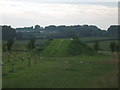
Strange Mini Golf Course near Bramling Road
This little earth mound beside an orchard has been turned into a Golf Tee.
No idea where the hole is ???
Highland Court Farm is in the background.
Image: © David Anstiss
Taken: 5 Sep 2010
0.06 miles
4
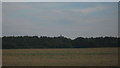
View of Water Tower in Woodlands Wood
As seen from Bramling Road.
Image: © David Anstiss
Taken: 5 Sep 2010
0.19 miles
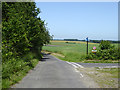
5
Road junction of Shepherd's Close Road
Shepherd's Close Road leads from Bramling Road straight on to Shepherd's Close Farm and then onwards via Keeper's Hill towards Patrixbourne.
Another lane leads right towards Chalk Pit Farm.
Image: © David Anstiss
Taken: 5 Sep 2010
0.21 miles
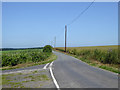
6
Shepherds Close Road
Towards Patrixbourne.
Image: © Robin Webster
Taken: 29 Jun 2019
0.22 miles
7
Lane towards Bekesbourne
It does not have an obvious name, but not needed for addresses, as, apart from a pillbox, it only has farmland to either side from end to end.
Image: © Robin Webster
Taken: 29 Jun 2019
0.23 miles