IMAGES TAKEN NEAR TO
Adisham Road, CANTERBURY, CT4 5HB
Introduction
This page details the photographs taken nearby to Adisham Road, CT4 5HB by members of the Geograph project.
The Geograph project started in 2005 with the aim of publishing, organising and preserving representative images for every square kilometre of Great Britain, Ireland and the Isle of Man.

There are currently over 7.5m images from over14,400 individuals and you can help contribute to the project by visiting https://www.geograph.org.uk
Image Map
Images are licensed for reuse under creativecommons.org/licenses/by-sa/2.0
Notes
- Clicking on the map will re-center to the selected point.
- The higher the marker number, the further away the image location is from the centre of the postcode.
Image Listing (22 Images Found)
Images are licensed for reuse under creativecommons.org/licenses/by-sa/2.0
Image
Details
Distance
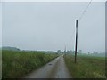
1
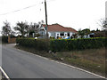
Larkshill on the brow of the hill, Adisham Road
Image: © Nick Smith
Taken: 14 Mar 2010
0.02 miles
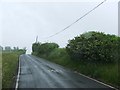
2
View along Adisham Road towards Downside
Downside is the row of 8 semi's on the left of the road
Image: © Nick Smith
Taken: 14 Mar 2010
0.07 miles
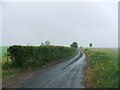
4
View along Adisham Downs Road
After the cross roads it becomes the Adisham Road
Image: © Nick Smith
Taken: 14 Mar 2010
0.10 miles
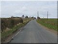
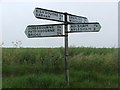
6
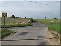
Bramling And Adisham Downs crossroads.
Bramling Road from Bramling leads straight on towards Bridge.
Adisham Downs Road leads right towards Bekesbourne and left towards Adisham.
Image: © David Anstiss
Taken: 5 Sep 2010
0.13 miles
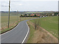
10
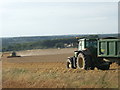
Harvest time
A large arable field being combine-harvested on a dry August afternoon. The curve of the harvester's path runs parallel with the public right of way between adjoining fields.
Image: © Ruth Riddle
Taken: 10 Aug 2011
0.19 miles