IMAGES TAKEN NEAR TO
Downside, Adisham Road, CANTERBURY, CT4 5HA
Introduction
This page details the photographs taken nearby to Downside, Adisham Road, CT4 5HA by members of the Geograph project.
The Geograph project started in 2005 with the aim of publishing, organising and preserving representative images for every square kilometre of Great Britain, Ireland and the Isle of Man.

There are currently over 7.5m images from over14,400 individuals and you can help contribute to the project by visiting https://www.geograph.org.uk
Image Map
Images are licensed for reuse under creativecommons.org/licenses/by-sa/2.0
Notes
- Clicking on the map will re-center to the selected point.
- The higher the marker number, the further away the image location is from the centre of the postcode.
Image Listing (28 Images Found)
Images are licensed for reuse under creativecommons.org/licenses/by-sa/2.0
Image
Details
Distance
1
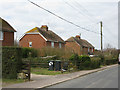
Downside, a row of 8 semi-detached house
Image: © Nick Smith
Taken: 14 Mar 2010
0.02 miles
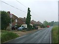

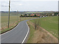
4
View along Aerodrome Road
The houses are part of the small De Havilland estate built on the site of Bekesbourne's former WW1 aerodrome.
Image: © Nick Smith
Taken: 25 Nov 2007
0.12 miles


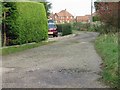
9
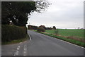
View along Adisham Road towards Downside
Downside is the row of 8 semi's on the left of the road
Image: © Nick Smith
Taken: 14 Mar 2010
0.15 miles
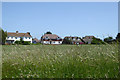
10
De Havillands, a small estate on the site of Bekesbourne's former aerodrome
Image: © Nick Smith
Taken: 25 Nov 2007
0.16 miles