IMAGES TAKEN NEAR TO
Aerodrome Road, CANTERBURY, CT4 5EX
Introduction
This page details the photographs taken nearby to Aerodrome Road, CT4 5EX by members of the Geograph project.
The Geograph project started in 2005 with the aim of publishing, organising and preserving representative images for every square kilometre of Great Britain, Ireland and the Isle of Man.

There are currently over 7.5m images from over14,400 individuals and you can help contribute to the project by visiting https://www.geograph.org.uk
Image Map
Images are licensed for reuse under creativecommons.org/licenses/by-sa/2.0
Notes
- Clicking on the map will re-center to the selected point.
- The higher the marker number, the further away the image location is from the centre of the postcode.
Image Listing (41 Images Found)
Images are licensed for reuse under creativecommons.org/licenses/by-sa/2.0
Image
Details
Distance
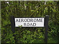
1
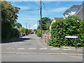
Aerodrome Road, Bekesbourne
Named after the WWI RAF aerodrome here, later a civil airfield. It closed early in WWII after a brief military revival.
Image: © Robin Webster
Taken: 4 Jun 2015
0.03 miles
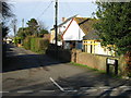

6
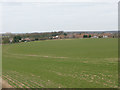
View of the small estate of De Havillands
This fairly new development was built on the site of Bekesbourne's former aerodrome.
Image: © Nick Smith
Taken: 14 Mar 2010
0.08 miles
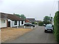

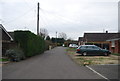
10
'De Havillands' a small estate of houses at Bekesbourne.
Built on the site of the old aerodrome. The aerodrome was built in 1916 and used for WW1 air defence, it became a civil airport after 1918 and closed in 1940.
Image: © Nick Smith
Taken: 14 Jan 2007
0.09 miles