IMAGES TAKEN NEAR TO
Oakleigh Lane, CANTERBURY, CT4 5EB
Introduction
This page details the photographs taken nearby to Oakleigh Lane, CT4 5EB by members of the Geograph project.
The Geograph project started in 2005 with the aim of publishing, organising and preserving representative images for every square kilometre of Great Britain, Ireland and the Isle of Man.

There are currently over 7.5m images from over14,400 individuals and you can help contribute to the project by visiting https://www.geograph.org.uk
Image Map
Images are licensed for reuse under creativecommons.org/licenses/by-sa/2.0
Notes
- Clicking on the map will re-center to the selected point.
- The higher the marker number, the further away the image location is from the centre of the postcode.
Image Listing (44 Images Found)
Images are licensed for reuse under creativecommons.org/licenses/by-sa/2.0
Image
Details
Distance
2
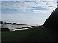
Polytunnels near Bekesbourne
A footpath leads up from Bekesbourne Hill.
Under the tunnels strawberries are still growing.
Image: © David Anstiss
Taken: 5 Sep 2010
0.11 miles
5
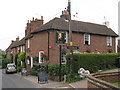
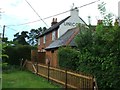
The Unicorn, Bekesbourne
Free house on Bekesbourne Hill.
Image: © Oast House Archive
Taken: 20 Jul 2010
0.14 miles
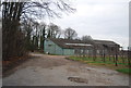
9
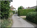
Small lane leading to the Unicorn car park
Taken from the car park looking towards Bekesbourne Hill
Image: © Nick Smith
Taken: 30 Sep 2007
0.14 miles