IMAGES TAKEN NEAR TO
The Cedars, CANTERBURY, CT4 5DS
Introduction
This page details the photographs taken nearby to The Cedars, CT4 5DS by members of the Geograph project.
The Geograph project started in 2005 with the aim of publishing, organising and preserving representative images for every square kilometre of Great Britain, Ireland and the Isle of Man.

There are currently over 7.5m images from over14,400 individuals and you can help contribute to the project by visiting https://www.geograph.org.uk
Image Map
Images are licensed for reuse under creativecommons.org/licenses/by-sa/2.0
Notes
- Clicking on the map will re-center to the selected point.
- The higher the marker number, the further away the image location is from the centre of the postcode.
Image Listing (34 Images Found)
Images are licensed for reuse under creativecommons.org/licenses/by-sa/2.0
Image
Details
Distance
7
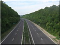
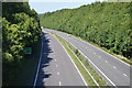
The A2 Dover Road heading towards Canterbury
As seen from Image
This dual carriageway heads from Dover, past Canterbury on its way towards the M2 Junction 7.
Image: © David Anstiss
Taken: 5 Sep 2010
0.10 miles
8
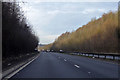
A2 towards London
Bypassing the old route through Bridge.
Image: © Robin Webster
Taken: 7 Feb 2020
0.11 miles