IMAGES TAKEN NEAR TO
Patrixbourne, CANTERBURY, CT4 5BP
Introduction
This page details the photographs taken nearby to CT4 5BP by members of the Geograph project.
The Geograph project started in 2005 with the aim of publishing, organising and preserving representative images for every square kilometre of Great Britain, Ireland and the Isle of Man.

There are currently over 7.5m images from over14,400 individuals and you can help contribute to the project by visiting https://www.geograph.org.uk
Image Map
Images are licensed for reuse under creativecommons.org/licenses/by-sa/2.0
Notes
- Clicking on the map will re-center to the selected point.
- The higher the marker number, the further away the image location is from the centre of the postcode.
Image Listing (220 Images Found)
Images are licensed for reuse under creativecommons.org/licenses/by-sa/2.0
Image
Details
Distance
1
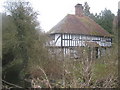
Bourne Cottage
Beside the Nailbourne. Seen from Patrixbourne Road.
Image: © David Anstiss
Taken: 26 Mar 2010
0.01 miles
2
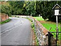
Patrixbourne Road, Patrixbourne
The entrance to St. Mary's Church is on the right.
Image: © pam fray
Taken: 27 Sep 2022
0.01 miles
3
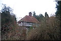
The Barton
Grade II listed , 15th century cottage. http://www.britishlistedbuildings.co.uk/en-171359-the-barton-bekesbourne-with-patrixbourne
Image: © N Chadwick
Taken: 8 Jan 2012
0.02 miles
4
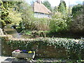
Looking across the Nail Bourne in Patrixbourne
Patrixbourne is a delightful village and is also on the North Downs Way which passes through it along The Street and Patrixbourne Road here. This picturesque scene is where Patrixbourne Road crosses the Nail Bourne.
The Nail Bourne flows from Lyminge, through the Elham Valley until it becomes known as the Little Stour at Littlebourne. Whilst the stream often holds a plentiful supply of water from Lyminge to Elham throughout the year, it apparently rarely holds any water from Elham to Bishopsbourne even in the winter months. Certainly when I was there in December 2013 it was completely dry as can be seen in the photograph at http://www.geograph.org.uk/photo/3763888 At Easter 2015 though, when this photograph was taken, it was flowing fast and clear.
The Little Stour then joins with the Great Stour at Plucks Gutter near West Stourmouth. A map of the Nail Bourne and more information about it can be seen at http://en.wikipedia.org/wiki/Little_Stour
Image: © Marathon
Taken: 5 Apr 2015
0.02 miles
5
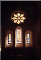
St Mary, Patrixbourne: Marigold window
The church is listed grade 1 (list entry number 1336572).
Image: © Stephen Craven
Taken: 12 Sep 1998
0.02 miles
6
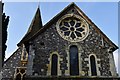
Patrixbourne: Church of St Mary
The west aspect of the church showing the rare Norman wheel window
Image: © Michael Garlick
Taken: 20 Nov 2014
0.02 miles
7
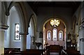
Patrixbourne: Church of St Mary
The Norman chancel arch is plain especially compared with the splendid exterior carvings; the north arcade dates from 1824 and the south arcade is 15th century
Image: © Michael Garlick
Taken: 20 Nov 2014
0.02 miles
9
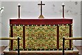
Patrixbourne, St. Mary's Church: The altar
Image: © Michael Garlick
Taken: 16 Aug 2021
0.02 miles
10

Patrixbourne, St. Mary's Church: East wheel window
Image: © Michael Garlick
Taken: 16 Aug 2021
0.02 miles