IMAGES TAKEN NEAR TO
CT3 4NT
Introduction
This page details the photographs taken nearby to CT3 4NT by members of the Geograph project.
The Geograph project started in 2005 with the aim of publishing, organising and preserving representative images for every square kilometre of Great Britain, Ireland and the Isle of Man.

There are currently over 7.5m images from over14,400 individuals and you can help contribute to the project by visiting https://www.geograph.org.uk
Image Map
Images are licensed for reuse under creativecommons.org/licenses/by-sa/2.0
Notes
- Clicking on the map will re-center to the selected point.
- The higher the marker number, the further away the image location is from the centre of the postcode.
Image Listing (12 Images Found)
Images are licensed for reuse under creativecommons.org/licenses/by-sa/2.0
Image
Details
Distance
1
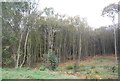
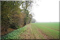
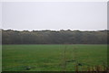
Calfs Wood
A southern extension of East Blean Wood.
Image: © N Chadwick
Taken: 12 Nov 2011
0.13 miles
3
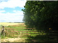
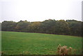
Gate near Calfs wood
This gate and stile is on footpath from Hoath Road, through Buckwell Farm towards Hick Forstal Road.
Image: © David Anstiss
Taken: 11 Jul 2010
0.18 miles
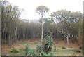
6
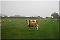
Cattle in a staring contest
These cattle seemed very interested in me as I entered their field.
Image: © N Chadwick
Taken: 12 Nov 2011
0.20 miles
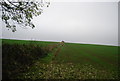
10
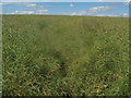
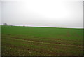
Is there a footpath here ??
Seen from Calf Wood. A footpath leads through this field of mature oil seed rape plants towards Woodlands Farm.f
Image: © David Anstiss
Taken: 11 Jul 2010
0.24 miles