IMAGES TAKEN NEAR TO
Calcott Hill, CANTERBURY, CT3 4ND
Introduction
This page details the photographs taken nearby to Calcott Hill, CT3 4ND by members of the Geograph project.
The Geograph project started in 2005 with the aim of publishing, organising and preserving representative images for every square kilometre of Great Britain, Ireland and the Isle of Man.

There are currently over 7.5m images from over14,400 individuals and you can help contribute to the project by visiting https://www.geograph.org.uk
Image Map
Images are licensed for reuse under creativecommons.org/licenses/by-sa/2.0
Notes
- Clicking on the map will re-center to the selected point.
- The higher the marker number, the further away the image location is from the centre of the postcode.
Image Listing (24 Images Found)
Images are licensed for reuse under creativecommons.org/licenses/by-sa/2.0
Image
Details
Distance
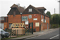
1
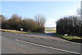
Entrance to Long Shaw Farm, Herne Bay Rd
Image: © N Chadwick
Taken: 31 Jan 2009
0.04 miles
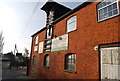
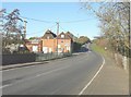
4
Oast House / Warehouse, Calcott
Now occupied by Bates, roofing contractors.
Image: © N Chadwick
Taken: 31 Jan 2009
0.07 miles
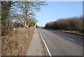
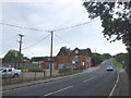
5
Herne Bay Road (A291) passing former oast-house
This is now occupied by Bates, whose notices on the building describe the firm as being in the business of plant hire and blast cleaning.
Image: © John Baker
Taken: 2 Dec 2012
0.08 miles
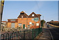
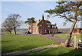
7
Calcott Oast, Calcott Hill, Sturry, Kent
Image: © Oast House Archive
Taken: 17 Apr 2009
0.08 miles
9
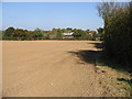
Looking N along field boundary towards Calcott
Image: © Nick Smith
Taken: 12 Oct 2008
0.11 miles
10
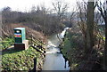
Gauging station on the Sarre Penn, Calcott
Image: © N Chadwick
Taken: 31 Jan 2009
0.14 miles