IMAGES TAKEN NEAR TO
Calcott, CANTERBURY, CT3 4NB
Introduction
This page details the photographs taken nearby to Calcott, CT3 4NB by members of the Geograph project.
The Geograph project started in 2005 with the aim of publishing, organising and preserving representative images for every square kilometre of Great Britain, Ireland and the Isle of Man.

There are currently over 7.5m images from over14,400 individuals and you can help contribute to the project by visiting https://www.geograph.org.uk
Image Map
Images are licensed for reuse under creativecommons.org/licenses/by-sa/2.0
Notes
- Clicking on the map will re-center to the selected point.
- The higher the marker number, the further away the image location is from the centre of the postcode.
Image Listing (29 Images Found)
Images are licensed for reuse under creativecommons.org/licenses/by-sa/2.0
Image
Details
Distance
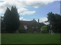
1
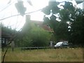
The Dower House
As seen from a track to Woodland Farm
Image: © David Anstiss
Taken: 11 Jul 2010
0.01 miles
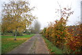
2
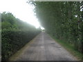
Track from Woodland Farm
This restricted byway leads from the farm towards the A291 Herne Bay Road.
Image: © David Anstiss
Taken: 11 Jul 2010
0.05 miles
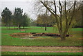
6
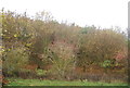
Woodlands Farm
As seen from a footpath from the A291 Herne Bay road towards Calfs Wood.
Image: © David Anstiss
Taken: 11 Jul 2010
0.08 miles
7
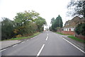
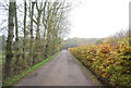
Canterbury Rd (A291)
The main road between Canterbury and Herne Bay.
Image: © N Chadwick
Taken: 12 Nov 2011
0.09 miles
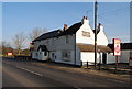
10
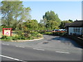
Entrance to the car park at the Punch Tavern
Off the Herne Bay Road between Sturry and Herne Bay
Image: © Nick Smith
Taken: 12 Oct 2008
0.09 miles