IMAGES TAKEN NEAR TO
Millbank, CANTERBURY, CT3 4LR
Introduction
This page details the photographs taken nearby to Millbank, CT3 4LR by members of the Geograph project.
The Geograph project started in 2005 with the aim of publishing, organising and preserving representative images for every square kilometre of Great Britain, Ireland and the Isle of Man.

There are currently over 7.5m images from over14,400 individuals and you can help contribute to the project by visiting https://www.geograph.org.uk
Image Map
Images are licensed for reuse under creativecommons.org/licenses/by-sa/2.0
Notes
- Clicking on the map will re-center to the selected point.
- The higher the marker number, the further away the image location is from the centre of the postcode.
Image Listing (17 Images Found)
Images are licensed for reuse under creativecommons.org/licenses/by-sa/2.0
Image
Details
Distance
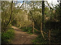
4
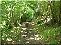
Dappled sunlight - path to Millbank through the wood
To the right of this scene is an 'off-road' track which utilises the steep gradient and muddy puddles!
Image: © Nick Smith
Taken: 7 Jul 2007
0.11 miles
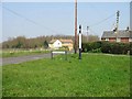
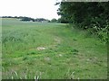
5
Footpath to Maypole Road
This path leads from a bridleway in Beacon Wood, then up a valley side through an off-road course (See Image) then it leads through a field towards Maypole.
Image: © David Anstiss
Taken: 25 Apr 2010
0.14 miles
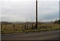
6
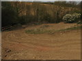
Off-road course near Beacon Wood
These tracks are part of a 4*4 activity course near Maypole Road. The course leads down a valley side and then into the wood (via dips and bumps), then it climbs back up the valley side.
See http://www.truegripoffroad.co.uk/res_website.asp?supplierCode=TGR100 for more details about the 'True Grip' course and activities.
On the left is a footpath fence leading through the course, from Maypole Road to Beacon Wood and a bridleway to Herne.
Image: © David Anstiss
Taken: 25 Apr 2010
0.15 miles
7
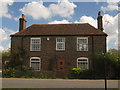
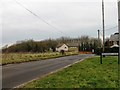
Forge House, Maypole
On Maypole Road. Opposite a footpath to Beacon Wood.
Image: © David Anstiss
Taken: 25 Apr 2010
0.15 miles
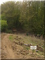
9
Bridleway and footpath junction in Beacon Wood
A bridleway (also known as Oldhawe Hill) from Ridgeway Road, Herne heads through the wood towards Maypole Road. A footpath heads right through a 4*4 off-road activity course before leading through a field towards Maypole Road.
Image: © David Anstiss
Taken: 25 Apr 2010
0.17 miles
10
Off road course in Beacon Wood
This track is part of a 4*4 activity course near Maypole Road.
See http://www.truegripoffroad.co.uk/res_website.asp?supplierCode=TGR100 for more details about the 'True Grip' course and activities.
Sign in the foreground refers to a footpath leading through the course, from Maypole Road to Beacon Wood and a bridleway to Herne.
Image: © David Anstiss
Taken: 25 Apr 2010
0.17 miles