IMAGES TAKEN NEAR TO
Maypole Lane, CANTERBURY, CT3 4LL
Introduction
This page details the photographs taken nearby to Maypole Lane, CT3 4LL by members of the Geograph project.
The Geograph project started in 2005 with the aim of publishing, organising and preserving representative images for every square kilometre of Great Britain, Ireland and the Isle of Man.

There are currently over 7.5m images from over14,400 individuals and you can help contribute to the project by visiting https://www.geograph.org.uk
Image Map
Images are licensed for reuse under creativecommons.org/licenses/by-sa/2.0
Notes
- Clicking on the map will re-center to the selected point.
- The higher the marker number, the further away the image location is from the centre of the postcode.
Image Listing (43 Images Found)
Images are licensed for reuse under creativecommons.org/licenses/by-sa/2.0
Image
Details
Distance
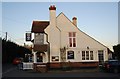
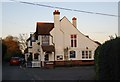
4
Prince of Wales Pub in Maypole near Hoath, Kent
Fresh supplies arriving from Britain's oldest (and best?) brewery
Image: © david mills
Taken: 25 Jun 2007
0.07 miles
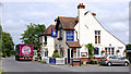
7
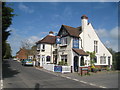
Prince of Wales, Maypole
On Maypole Road, at junction of Maypole Lane
Image: © Oast House Archive
Taken: 7 May 2010
0.08 miles
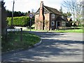
10
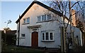
Chapel House
An old Wesleyan Chapel dated from 1860, converted to a residence.
Image: © N Chadwick
Taken: 10 Dec 2011
0.09 miles