IMAGES TAKEN NEAR TO
Shelvingford, CANTERBURY, CT3 4LG
Introduction
This page details the photographs taken nearby to Shelvingford, CT3 4LG by members of the Geograph project.
The Geograph project started in 2005 with the aim of publishing, organising and preserving representative images for every square kilometre of Great Britain, Ireland and the Isle of Man.

There are currently over 7.5m images from over14,400 individuals and you can help contribute to the project by visiting https://www.geograph.org.uk
Image Map
Images are licensed for reuse under creativecommons.org/licenses/by-sa/2.0
Notes
- Clicking on the map will re-center to the selected point.
- The higher the marker number, the further away the image location is from the centre of the postcode.
Image Listing (14 Images Found)
Images are licensed for reuse under creativecommons.org/licenses/by-sa/2.0
Image
Details
Distance
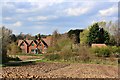
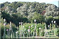
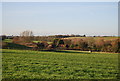
4
View from field of Shelvingford Farm
Image: © Francesca Wilkinson
Taken: 5 Jul 2008
0.05 miles
5
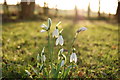
Snowdrops in my garden in Shelvingford Farm
Image: © Francesca Wilkinson
Taken: 27 Apr 2008
0.06 miles
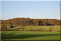
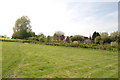
6
View from field of Shelvingford with part of Shelving wood in the background.
Image: © Francesca Wilkinson
Taken: 22 Jul 2008
0.06 miles
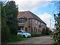
7
Shelvingford Farm
In the distance are the tops of Ford Manor Farm Oasts.
Image: © N Chadwick
Taken: 10 Dec 2011
0.08 miles
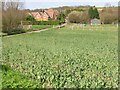
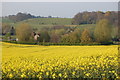
8
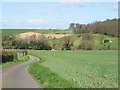
View across farmland towards Shelving Wood
Image: © Nick Smith
Taken: 18 Mar 2007
0.13 miles