IMAGES TAKEN NEAR TO
Hoath, CANTERBURY, CT3 4LF
Introduction
This page details the photographs taken nearby to CT3 4LF by members of the Geograph project.
The Geograph project started in 2005 with the aim of publishing, organising and preserving representative images for every square kilometre of Great Britain, Ireland and the Isle of Man.

There are currently over 7.5m images from over14,400 individuals and you can help contribute to the project by visiting https://www.geograph.org.uk
Image Map
Images are licensed for reuse under creativecommons.org/licenses/by-sa/2.0
Notes
- Clicking on the map will re-center to the selected point.
- The higher the marker number, the further away the image location is from the centre of the postcode.
Image Listing (14 Images Found)
Images are licensed for reuse under creativecommons.org/licenses/by-sa/2.0
Image
Details
Distance
1

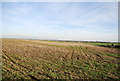
View from Hollow Road
Looking eastwards towards Marley Pits near Boyden Gate.
Image: © David Anstiss
Taken: 24 Oct 2010
0.09 miles


6

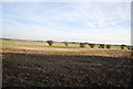
Oilseed Rape
Viewed from junction of Hollow Road, Mill Road, and Old Tree Road. Hollow Road seen straight ahead.
Image: © Oast House Archive
Taken: 7 May 2010
0.19 miles


9

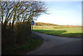
Road junction near Maypole
Hollow Road leads from Chislet straight on towards Maypole and Hoath.
Old Tree Road leads right towards Boyden Gate.
Image: © David Anstiss
Taken: 24 Oct 2010
0.21 miles